You are here: Home > Network List > CN - Canadian National Seismograph Network Stations List
> Station KILO Kirkland Lake, ON, CA > Earthquake Result Viewer
KILO Kirkland Lake, ON, CA - Earthquake Result Viewer
| Earthquake location: |
Kuril Islands |
| Earthquake latitude/longitude: |
44.0/147.9 |
| Earthquake time(UTC): |
2015/07/07 (188) 05:10:27 GMT |
| Earthquake Depth: |
38 km |
| Earthquake Magnitude: |
6.3 MO |
| Earthquake Catalog/Contributor: |
NEIC PDE/NEIC ALERT |
|
| Network: |
CN Canadian National Seismograph Network |
| Station: |
KILO Kirkland Lake, ON, CA |
| Lat/Lon: |
48.50 N/79.72 W |
| Elevation: |
314 m |
|
| Distance: |
78.8 deg |
| Az: |
30.073 deg |
| Baz: |
327.056 deg |
| Ray Param: |
0.04930483 |
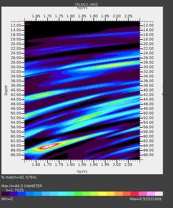
| Estimated Moho Depth: |
64.0 km |
| Estimated Crust Vp/Vs: |
1.70 |
| Assumed Crust Vp: |
6.61 km/s |
| Estimated Crust Vs: |
3.883 km/s |
| Estimated Crust Poisson's Ratio: |
0.24 |
|
| Radial Match: |
81.57941 % |
| Radial Bump: |
400 |
| Transverse Match: |
62.14743 % |
| Transverse Bump: |
400 |
| SOD ConfigId: |
7422571 |
| Insert Time: |
2019-04-19 16:11:26.523 +0000 |
| GWidth: |
2.5 |
| Max Bumps: |
400 |
| Tol: |
0.001 |
|

Signal To Noise
| Channel | StoN | STA | LTA |
| CN:KILO: :HHZ:20150707T05:21:54.419971Z | 20.426836 | 3.2760474E-6 | 1.6037959E-7 |
| CN:KILO: :HHN:20150707T05:21:54.419971Z | 7.530844 | 1.3083354E-6 | 1.7373024E-7 |
| CN:KILO: :HHE:20150707T05:21:54.419971Z | 2.4784176 | 7.9770217E-7 | 3.218595E-7 |
| Arrivals |
| Ps | 7.0 SECOND |
| PpPs | 25 SECOND |
| PsPs/PpSs | 32 SECOND |


