You are here: Home > Network List > CN - Canadian National Seismograph Network Stations List
> Station WHY Whitehorse, YT, CA > Earthquake Result Viewer
WHY Whitehorse, YT, CA - Earthquake Result Viewer
| Earthquake location: |
Kuril Islands |
| Earthquake latitude/longitude: |
44.0/147.9 |
| Earthquake time(UTC): |
2015/07/07 (188) 05:10:27 GMT |
| Earthquake Depth: |
38 km |
| Earthquake Magnitude: |
6.3 MO |
| Earthquake Catalog/Contributor: |
NEIC PDE/NEIC ALERT |
|
| Network: |
CN Canadian National Seismograph Network |
| Station: |
WHY Whitehorse, YT, CA |
| Lat/Lon: |
60.66 N/134.88 W |
| Elevation: |
1273 m |
|
| Distance: |
47.1 deg |
| Az: |
40.991 deg |
| Baz: |
285.972 deg |
| Ray Param: |
0.07015302 |
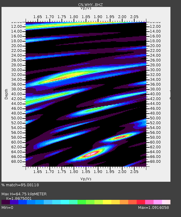
| Estimated Moho Depth: |
64.75 km |
| Estimated Crust Vp/Vs: |
1.87 |
| Assumed Crust Vp: |
6.419 km/s |
| Estimated Crust Vs: |
3.437 km/s |
| Estimated Crust Poisson's Ratio: |
0.30 |
|
| Radial Match: |
95.08118 % |
| Radial Bump: |
400 |
| Transverse Match: |
85.97152 % |
| Transverse Bump: |
400 |
| SOD ConfigId: |
7422571 |
| Insert Time: |
2019-04-19 16:11:47.024 +0000 |
| GWidth: |
2.5 |
| Max Bumps: |
400 |
| Tol: |
0.001 |
|
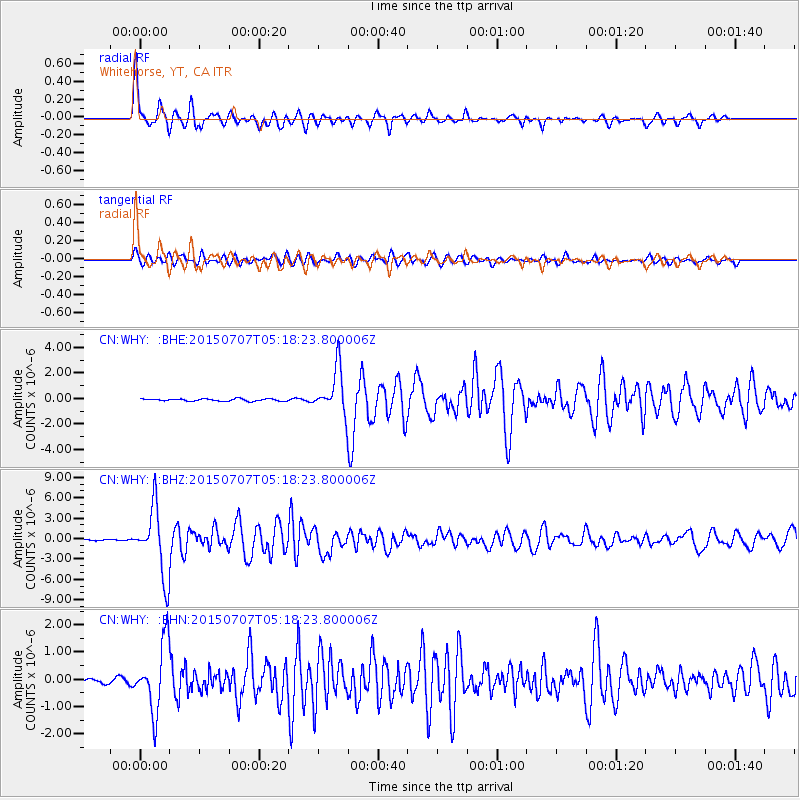
Signal To Noise
| Channel | StoN | STA | LTA |
| CN:WHY: :BHZ:20150707T05:18:23.800006Z | 68.45169 | 5.052414E-6 | 7.380993E-8 |
| CN:WHY: :BHN:20150707T05:18:23.800006Z | 18.248316 | 1.252196E-6 | 6.8619805E-8 |
| CN:WHY: :BHE:20150707T05:18:23.800006Z | 29.154776 | 2.5777724E-6 | 8.841682E-8 |
| Arrivals |
| Ps | 9.3 SECOND |
| PpPs | 27 SECOND |
| PsPs/PpSs | 37 SECOND |


