You are here: Home > Network List > GB - Great Britain Seismograph Network Stations List
> Station HPK HAVERAH PARK, ENGLAND > Earthquake Result Viewer
HPK HAVERAH PARK, ENGLAND - Earthquake Result Viewer
| Earthquake location: |
Kuril Islands |
| Earthquake latitude/longitude: |
44.0/147.9 |
| Earthquake time(UTC): |
2015/07/07 (188) 05:10:27 GMT |
| Earthquake Depth: |
38 km |
| Earthquake Magnitude: |
6.3 MO |
| Earthquake Catalog/Contributor: |
NEIC PDE/NEIC ALERT |
|
| Network: |
GB Great Britain Seismograph Network |
| Station: |
HPK HAVERAH PARK, ENGLAND |
| Lat/Lon: |
53.96 N/1.62 W |
| Elevation: |
233 m |
|
| Distance: |
79.0 deg |
| Az: |
342.243 deg |
| Baz: |
21.872 deg |
| Ray Param: |
0.049190816 |
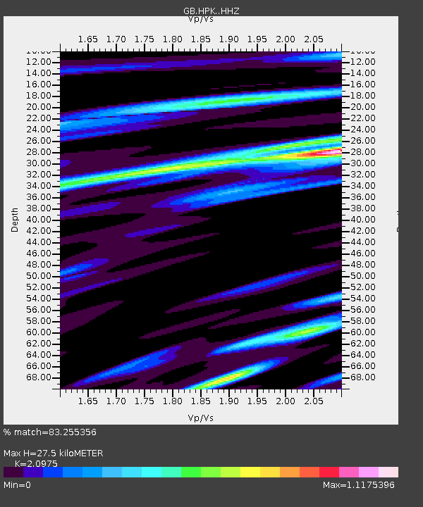
| Estimated Moho Depth: |
27.5 km |
| Estimated Crust Vp/Vs: |
2.10 |
| Assumed Crust Vp: |
6.276 km/s |
| Estimated Crust Vs: |
2.992 km/s |
| Estimated Crust Poisson's Ratio: |
0.35 |
|
| Radial Match: |
83.255356 % |
| Radial Bump: |
400 |
| Transverse Match: |
65.372696 % |
| Transverse Bump: |
400 |
| SOD ConfigId: |
7422571 |
| Insert Time: |
2019-04-19 16:12:16.811 +0000 |
| GWidth: |
2.5 |
| Max Bumps: |
400 |
| Tol: |
0.001 |
|

Signal To Noise
| Channel | StoN | STA | LTA |
| GB:HPK: :HHZ:20150707T05:21:55.559985Z | 26.789936 | 1.02226895E-5 | 3.8158691E-7 |
| GB:HPK: :HHN:20150707T05:21:55.559985Z | 7.6090484 | 3.431899E-6 | 4.5102868E-7 |
| GB:HPK: :HHE:20150707T05:21:55.559985Z | 3.3541842 | 1.7012109E-6 | 5.0719063E-7 |
| Arrivals |
| Ps | 4.9 SECOND |
| PpPs | 13 SECOND |
| PsPs/PpSs | 18 SECOND |


