You are here: Home > Network List > GB - Great Britain Seismograph Network Stations List
> Station WLF1 LLYNFAES, WALES > Earthquake Result Viewer
WLF1 LLYNFAES, WALES - Earthquake Result Viewer
| Earthquake location: |
Kuril Islands |
| Earthquake latitude/longitude: |
44.0/147.9 |
| Earthquake time(UTC): |
2015/07/07 (188) 05:10:27 GMT |
| Earthquake Depth: |
38 km |
| Earthquake Magnitude: |
6.3 MO |
| Earthquake Catalog/Contributor: |
NEIC PDE/NEIC ALERT |
|
| Network: |
GB Great Britain Seismograph Network |
| Station: |
WLF1 LLYNFAES, WALES |
| Lat/Lon: |
53.29 N/4.40 W |
| Elevation: |
66 m |
|
| Distance: |
80.2 deg |
| Az: |
343.569 deg |
| Baz: |
19.883 deg |
| Ray Param: |
0.048360243 |
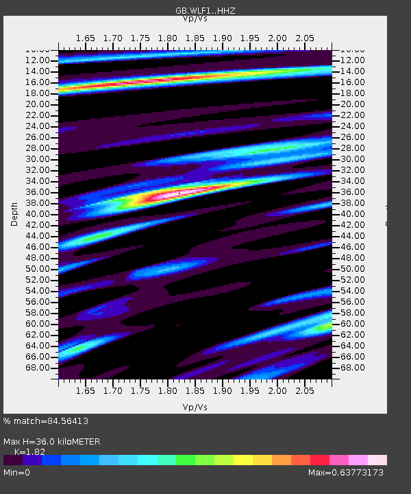
| Estimated Moho Depth: |
36.0 km |
| Estimated Crust Vp/Vs: |
1.82 |
| Assumed Crust Vp: |
6.182 km/s |
| Estimated Crust Vs: |
3.397 km/s |
| Estimated Crust Poisson's Ratio: |
0.28 |
|
| Radial Match: |
84.56413 % |
| Radial Bump: |
301 |
| Transverse Match: |
67.32219 % |
| Transverse Bump: |
400 |
| SOD ConfigId: |
7422571 |
| Insert Time: |
2019-04-19 16:12:23.712 +0000 |
| GWidth: |
2.5 |
| Max Bumps: |
400 |
| Tol: |
0.001 |
|

Signal To Noise
| Channel | StoN | STA | LTA |
| GB:WLF1: :HHZ:20150707T05:22:02.119983Z | 16.076332 | 1.4978983E-5 | 9.317414E-7 |
| GB:WLF1: :HHN:20150707T05:22:02.119983Z | 12.196502 | 5.6681406E-6 | 4.647349E-7 |
| GB:WLF1: :HHE:20150707T05:22:02.119983Z | 2.4683385 | 1.70546E-6 | 6.909344E-7 |
| Arrivals |
| Ps | 4.9 SECOND |
| PpPs | 16 SECOND |
| PsPs/PpSs | 21 SECOND |


