You are here: Home > Network List > IM - International Miscellaneous Stations Stations List
> Station TX32 Lajitas Array Site 32 (same as tx01 and TX00) > Earthquake Result Viewer
TX32 Lajitas Array Site 32 (same as tx01 and TX00) - Earthquake Result Viewer
| Earthquake location: |
Kuril Islands |
| Earthquake latitude/longitude: |
44.0/147.9 |
| Earthquake time(UTC): |
2015/07/07 (188) 05:10:27 GMT |
| Earthquake Depth: |
38 km |
| Earthquake Magnitude: |
6.3 MO |
| Earthquake Catalog/Contributor: |
NEIC PDE/NEIC ALERT |
|
| Network: |
IM International Miscellaneous Stations |
| Station: |
TX32 Lajitas Array Site 32 (same as tx01 and TX00) |
| Lat/Lon: |
29.33 N/103.67 W |
| Elevation: |
996 m |
|
| Distance: |
82.0 deg |
| Az: |
56.784 deg |
| Baz: |
316.243 deg |
| Ray Param: |
0.04710379 |
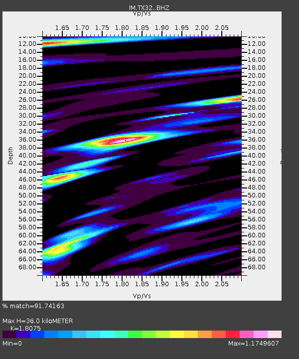
| Estimated Moho Depth: |
36.0 km |
| Estimated Crust Vp/Vs: |
1.81 |
| Assumed Crust Vp: |
6.419 km/s |
| Estimated Crust Vs: |
3.551 km/s |
| Estimated Crust Poisson's Ratio: |
0.28 |
|
| Radial Match: |
91.74163 % |
| Radial Bump: |
400 |
| Transverse Match: |
91.33407 % |
| Transverse Bump: |
400 |
| SOD ConfigId: |
7422571 |
| Insert Time: |
2019-04-19 16:13:08.908 +0000 |
| GWidth: |
2.5 |
| Max Bumps: |
400 |
| Tol: |
0.001 |
|

Signal To Noise
| Channel | StoN | STA | LTA |
| IM:TX32: :BHZ:20150707T05:22:11.374988Z | 108.544304 | 5.332086E-6 | 4.9123592E-8 |
| IM:TX32: :BHN:20150707T05:22:11.374988Z | 12.56314 | 1.4186107E-6 | 1.12918485E-7 |
| IM:TX32: :BHE:20150707T05:22:11.374988Z | 20.386461 | 2.047665E-6 | 1.0044239E-7 |
| Arrivals |
| Ps | 4.6 SECOND |
| PpPs | 15 SECOND |
| PsPs/PpSs | 20 SECOND |


