You are here: Home > Network List > KR - Kyrgyz Digital Network Stations List
> Station DRK Karamyk, Kyrgyzstan > Earthquake Result Viewer
DRK Karamyk, Kyrgyzstan - Earthquake Result Viewer
| Earthquake location: |
Kuril Islands |
| Earthquake latitude/longitude: |
44.0/147.9 |
| Earthquake time(UTC): |
2015/07/07 (188) 05:10:27 GMT |
| Earthquake Depth: |
38 km |
| Earthquake Magnitude: |
6.3 MO |
| Earthquake Catalog/Contributor: |
NEIC PDE/NEIC ALERT |
|
| Network: |
KR Kyrgyz Digital Network |
| Station: |
DRK Karamyk, Kyrgyzstan |
| Lat/Lon: |
39.48 N/71.80 E |
| Elevation: |
2627 m |
|
| Distance: |
55.1 deg |
| Az: |
293.632 deg |
| Baz: |
58.701 deg |
| Ray Param: |
0.06493749 |
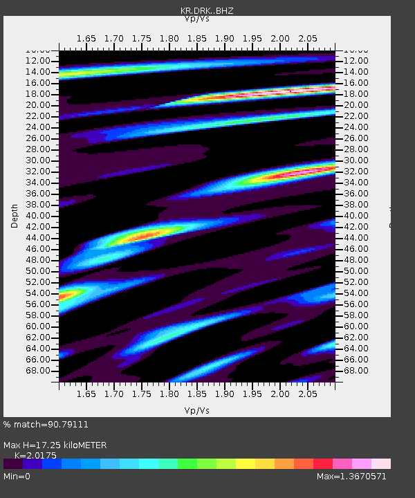
| Estimated Moho Depth: |
17.25 km |
| Estimated Crust Vp/Vs: |
2.02 |
| Assumed Crust Vp: |
6.306 km/s |
| Estimated Crust Vs: |
3.126 km/s |
| Estimated Crust Poisson's Ratio: |
0.34 |
|
| Radial Match: |
90.79111 % |
| Radial Bump: |
400 |
| Transverse Match: |
83.99943 % |
| Transverse Bump: |
400 |
| SOD ConfigId: |
7422571 |
| Insert Time: |
2019-04-19 16:13:37.607 +0000 |
| GWidth: |
2.5 |
| Max Bumps: |
400 |
| Tol: |
0.001 |
|

Signal To Noise
| Channel | StoN | STA | LTA |
| KR:DRK: :BHZ:20150707T05:19:24.475024Z | 26.924128 | 4.817147E-6 | 1.7891561E-7 |
| KR:DRK: :BHN:20150707T05:19:24.475024Z | 5.0182815 | 1.6435552E-6 | 3.2751356E-7 |
| KR:DRK: :BHE:20150707T05:19:24.475024Z | 8.145351 | 2.6278435E-6 | 3.226188E-7 |
| Arrivals |
| Ps | 2.9 SECOND |
| PpPs | 7.9 SECOND |
| PsPs/PpSs | 11 SECOND |


