You are here: Home > Network List > LD - Lamont-Doherty Cooperative Seismographic Network Stations List
> Station TUPA Temple University, Pennsylvania > Earthquake Result Viewer
TUPA Temple University, Pennsylvania - Earthquake Result Viewer
| Earthquake location: |
Kuril Islands |
| Earthquake latitude/longitude: |
44.0/147.9 |
| Earthquake time(UTC): |
2015/07/07 (188) 05:10:27 GMT |
| Earthquake Depth: |
38 km |
| Earthquake Magnitude: |
6.3 MO |
| Earthquake Catalog/Contributor: |
NEIC PDE/NEIC ALERT |
|
| Network: |
LD Lamont-Doherty Cooperative Seismographic Network |
| Station: |
TUPA Temple University, Pennsylvania |
| Lat/Lon: |
40.17 N/75.19 W |
| Elevation: |
112 m |
|
| Distance: |
87.7 deg |
| Az: |
31.618 deg |
| Baz: |
330.407 deg |
| Ray Param: |
0.043113075 |
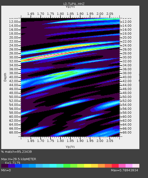
| Estimated Moho Depth: |
29.5 km |
| Estimated Crust Vp/Vs: |
1.72 |
| Assumed Crust Vp: |
6.283 km/s |
| Estimated Crust Vs: |
3.658 km/s |
| Estimated Crust Poisson's Ratio: |
0.24 |
|
| Radial Match: |
95.23439 % |
| Radial Bump: |
362 |
| Transverse Match: |
81.507195 % |
| Transverse Bump: |
400 |
| SOD ConfigId: |
7422571 |
| Insert Time: |
2019-04-19 16:14:10.868 +0000 |
| GWidth: |
2.5 |
| Max Bumps: |
400 |
| Tol: |
0.001 |
|

Signal To Noise
| Channel | StoN | STA | LTA |
| LD:TUPA: :HHZ:20150707T05:22:39.56499Z | 41.239597 | 3.7175644E-6 | 9.014551E-8 |
| LD:TUPA: :HHN:20150707T05:22:39.56499Z | 12.606951 | 1.0769219E-6 | 8.542287E-8 |
| LD:TUPA: :HHE:20150707T05:22:39.56499Z | 7.7596216 | 6.5137976E-7 | 8.3944784E-8 |
| Arrivals |
| Ps | 3.4 SECOND |
| PpPs | 12 SECOND |
| PsPs/PpSs | 16 SECOND |


