You are here: Home > Network List > MN - MEDNET Project Stations List
> Station VTS Vitosha, Bulgary > Earthquake Result Viewer
VTS Vitosha, Bulgary - Earthquake Result Viewer

| Earthquake location: |
Kuril Islands |
| Earthquake latitude/longitude: |
44.0/147.9 |
| Earthquake time(UTC): |
2015/07/07 (188) 05:10:27 GMT |
| Earthquake Depth: |
38 km |
| Earthquake Magnitude: |
6.3 MO |
| Earthquake Catalog/Contributor: |
NEIC PDE/NEIC ALERT |
|
| Network: |
MN MEDNET Project |
| Station: |
VTS Vitosha, Bulgary |
| Lat/Lon: |
42.62 N/23.24 E |
| Elevation: |
1490 m |
|
| Distance: |
80.6 deg |
| Az: |
322.038 deg |
| Baz: |
36.981 deg |
| Ray Param: |
0.04811931 |
| Estimated Moho Depth: |
35.0 km |
| Estimated Crust Vp/Vs: |
1.92 |
| Assumed Crust Vp: |
6.291 km/s |
| Estimated Crust Vs: |
3.272 km/s |
| Estimated Crust Poisson's Ratio: |
0.31 |
|
| Radial Match: |
95.10937 % |
| Radial Bump: |
400 |
| Transverse Match: |
94.99305 % |
| Transverse Bump: |
400 |
| SOD ConfigId: |
7422571 |
| Insert Time: |
2019-04-19 16:14:20.950 +0000 |
| GWidth: |
2.5 |
| Max Bumps: |
400 |
| Tol: |
0.001 |
|
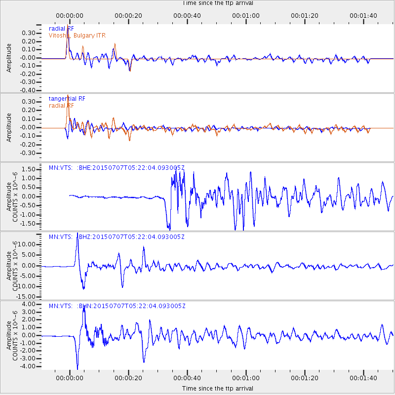
Signal To Noise
| Channel | StoN | STA | LTA |
| MN:VTS: :BHZ:20150707T05:22:04.093005Z | 116.04882 | 6.090248E-6 | 5.248005E-8 |
| MN:VTS: :BHN:20150707T05:22:04.093005Z | 67.94219 | 1.6587168E-6 | 2.4413648E-8 |
| MN:VTS: :BHE:20150707T05:22:04.093005Z | 24.66625 | 8.70729E-7 | 3.5300424E-8 |
| Arrivals |
| Ps | 5.3 SECOND |
| PpPs | 16 SECOND |
| PsPs/PpSs | 21 SECOND |


