You are here: Home > Network List > IU - Global Seismograph Network (GSN - IRIS/USGS) Stations List
> Station ULN Ulaanbaatar, Mongolia > Earthquake Result Viewer
ULN Ulaanbaatar, Mongolia - Earthquake Result Viewer
| Earthquake location: |
Flores Region, Indonesia |
| Earthquake latitude/longitude: |
-8.3/120.7 |
| Earthquake time(UTC): |
2003/03/25 (084) 02:53:25 GMT |
| Earthquake Depth: |
33 km |
| Earthquake Magnitude: |
6.2 MB, 6.1 MS, 6.5 MW, 6.3 MW |
| Earthquake Catalog/Contributor: |
WHDF/NEIC |
|
| Network: |
IU Global Seismograph Network (GSN - IRIS/USGS) |
| Station: |
ULN Ulaanbaatar, Mongolia |
| Lat/Lon: |
47.87 N/107.05 E |
| Elevation: |
1610 m |
|
| Distance: |
57.2 deg |
| Az: |
349.073 deg |
| Baz: |
163.823 deg |
| Ray Param: |
0.06357729 |
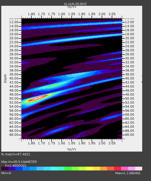
| Estimated Moho Depth: |
49.5 km |
| Estimated Crust Vp/Vs: |
1.68 |
| Assumed Crust Vp: |
6.642 km/s |
| Estimated Crust Vs: |
3.953 km/s |
| Estimated Crust Poisson's Ratio: |
0.23 |
|
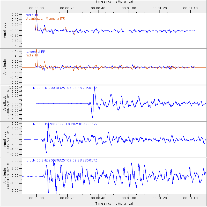
| Radial Match: |
97.4621 % |
| Radial Bump: |
250 |
| Transverse Match: |
90.82206 % |
| Transverse Bump: |
400 |
| SOD ConfigId: |
4714 |
| Insert Time: |
2010-03-03 15:52:55.495 +0000 |
| GWidth: |
2.5 |
| Max Bumps: |
400 |
| Tol: |
0.001 |
|
Signal To Noise
| Channel | StoN | STA | LTA |
| IU:ULN:00:BHN:20030325T03:02:38.235017Z | 6.698118 | 2.4138416E-7 | 3.603761E-8 |
| IU:ULN:00:BHE:20030325T03:02:38.235017Z | 1.4875367 | 6.0447086E-8 | 4.063569E-8 |
| IU:ULN:00:BHZ:20030325T03:02:38.235017Z | 8.619291 | 4.6566942E-7 | 5.402642E-8 |
| Arrivals |
| Ps | 5.4 SECOND |
| PpPs | 19 SECOND |
| PsPs/PpSs | 24 SECOND |


