You are here: Home > Network List > N4 - Central and EAstern US Network Stations List
> Station B35B Bob, Littlefork, MN, USA > Earthquake Result Viewer
B35B Bob, Littlefork, MN, USA - Earthquake Result Viewer
| Earthquake location: |
Kuril Islands |
| Earthquake latitude/longitude: |
44.0/147.9 |
| Earthquake time(UTC): |
2015/07/07 (188) 05:10:27 GMT |
| Earthquake Depth: |
38 km |
| Earthquake Magnitude: |
6.3 MO |
| Earthquake Catalog/Contributor: |
NEIC PDE/NEIC ALERT |
|
| Network: |
N4 Central and EAstern US Network |
| Station: |
B35B Bob, Littlefork, MN, USA |
| Lat/Lon: |
48.36 N/93.73 W |
| Elevation: |
354 m |
|
| Distance: |
73.3 deg |
| Az: |
37.794 deg |
| Baz: |
318.45 deg |
| Ray Param: |
0.053026047 |
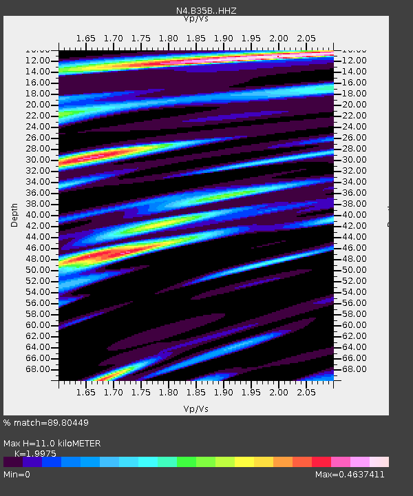
| Estimated Moho Depth: |
11.0 km |
| Estimated Crust Vp/Vs: |
2.00 |
| Assumed Crust Vp: |
6.419 km/s |
| Estimated Crust Vs: |
3.214 km/s |
| Estimated Crust Poisson's Ratio: |
0.33 |
|
| Radial Match: |
89.80449 % |
| Radial Bump: |
400 |
| Transverse Match: |
78.69958 % |
| Transverse Bump: |
400 |
| SOD ConfigId: |
7422571 |
| Insert Time: |
2019-04-19 16:14:40.984 +0000 |
| GWidth: |
2.5 |
| Max Bumps: |
400 |
| Tol: |
0.001 |
|

Signal To Noise
| Channel | StoN | STA | LTA |
| N4:B35B: :HHZ:20150707T05:21:22.999988Z | 41.094616 | 3.7946452E-6 | 9.2339235E-8 |
| N4:B35B: :HHN:20150707T05:21:22.999988Z | 7.198332 | 8.8291875E-7 | 1.2265602E-7 |
| N4:B35B: :HHE:20150707T05:21:22.999988Z | 7.4801674 | 9.565697E-7 | 1.278808E-7 |
| Arrivals |
| Ps | 1.8 SECOND |
| PpPs | 5.0 SECOND |
| PsPs/PpSs | 6.7 SECOND |


