You are here: Home > Network List > N4 - Central and EAstern US Network Stations List
> Station E28B Huff Hills, Mandan, ND, USA > Earthquake Result Viewer
E28B Huff Hills, Mandan, ND, USA - Earthquake Result Viewer
| Earthquake location: |
Kuril Islands |
| Earthquake latitude/longitude: |
44.0/147.9 |
| Earthquake time(UTC): |
2015/07/07 (188) 05:10:27 GMT |
| Earthquake Depth: |
38 km |
| Earthquake Magnitude: |
6.3 MO |
| Earthquake Catalog/Contributor: |
NEIC PDE/NEIC ALERT |
|
| Network: |
N4 Central and EAstern US Network |
| Station: |
E28B Huff Hills, Mandan, ND, USA |
| Lat/Lon: |
46.57 N/100.69 W |
| Elevation: |
704 m |
|
| Distance: |
71.4 deg |
| Az: |
42.684 deg |
| Baz: |
314.813 deg |
| Ray Param: |
0.054315083 |
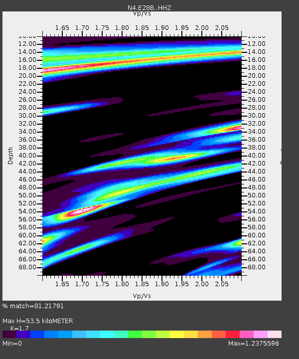
| Estimated Moho Depth: |
53.5 km |
| Estimated Crust Vp/Vs: |
1.70 |
| Assumed Crust Vp: |
6.438 km/s |
| Estimated Crust Vs: |
3.787 km/s |
| Estimated Crust Poisson's Ratio: |
0.24 |
|
| Radial Match: |
81.21791 % |
| Radial Bump: |
352 |
| Transverse Match: |
62.8016 % |
| Transverse Bump: |
378 |
| SOD ConfigId: |
7422571 |
| Insert Time: |
2019-04-19 16:14:44.262 +0000 |
| GWidth: |
2.5 |
| Max Bumps: |
400 |
| Tol: |
0.001 |
|

Signal To Noise
| Channel | StoN | STA | LTA |
| N4:E28B: :HHZ:20150707T05:21:11.390002Z | 30.38539 | 3.2960008E-6 | 1.08473216E-7 |
| N4:E28B: :HHN:20150707T05:21:11.390002Z | 2.9618845 | 1.2106889E-6 | 4.0875628E-7 |
| N4:E28B: :HHE:20150707T05:21:11.390002Z | 5.6636415 | 1.2641196E-6 | 2.231991E-7 |
| Arrivals |
| Ps | 6.0 SECOND |
| PpPs | 22 SECOND |
| PsPs/PpSs | 28 SECOND |


