You are here: Home > Network List > N4 - Central and EAstern US Network Stations List
> Station K43A Burlington, WI, USA > Earthquake Result Viewer
K43A Burlington, WI, USA - Earthquake Result Viewer
| Earthquake location: |
Kuril Islands |
| Earthquake latitude/longitude: |
44.0/147.9 |
| Earthquake time(UTC): |
2015/07/07 (188) 05:10:27 GMT |
| Earthquake Depth: |
38 km |
| Earthquake Magnitude: |
6.3 MO |
| Earthquake Catalog/Contributor: |
NEIC PDE/NEIC ALERT |
|
| Network: |
N4 Central and EAstern US Network |
| Station: |
K43A Burlington, WI, USA |
| Lat/Lon: |
42.70 N/88.33 W |
| Elevation: |
264 m |
|
| Distance: |
80.1 deg |
| Az: |
38.486 deg |
| Baz: |
322.453 deg |
| Ray Param: |
0.04846084 |
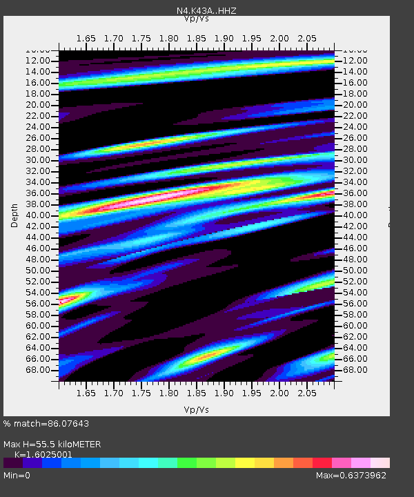
| Estimated Moho Depth: |
55.5 km |
| Estimated Crust Vp/Vs: |
1.60 |
| Assumed Crust Vp: |
6.571 km/s |
| Estimated Crust Vs: |
4.1 km/s |
| Estimated Crust Poisson's Ratio: |
0.18 |
|
| Radial Match: |
86.07643 % |
| Radial Bump: |
352 |
| Transverse Match: |
74.2377 % |
| Transverse Bump: |
400 |
| SOD ConfigId: |
7422571 |
| Insert Time: |
2019-04-19 16:14:59.712 +0000 |
| GWidth: |
2.5 |
| Max Bumps: |
400 |
| Tol: |
0.001 |
|

Signal To Noise
| Channel | StoN | STA | LTA |
| N4:K43A: :HHZ:20150707T05:22:01.069995Z | 16.44993 | 2.6605117E-6 | 1.6173392E-7 |
| N4:K43A: :HHN:20150707T05:22:01.069995Z | 6.599476 | 1.0025126E-6 | 1.5190791E-7 |
| N4:K43A: :HHE:20150707T05:22:01.069995Z | 8.305626 | 8.647137E-7 | 1.04111805E-7 |
| Arrivals |
| Ps | 5.3 SECOND |
| PpPs | 21 SECOND |
| PsPs/PpSs | 27 SECOND |


