You are here: Home > Network List > N4 - Central and EAstern US Network Stations List
> Station L34B Svendsen Farm, Lyons, NE, USA > Earthquake Result Viewer
L34B Svendsen Farm, Lyons, NE, USA - Earthquake Result Viewer
| Earthquake location: |
Kuril Islands |
| Earthquake latitude/longitude: |
44.0/147.9 |
| Earthquake time(UTC): |
2015/07/07 (188) 05:10:27 GMT |
| Earthquake Depth: |
38 km |
| Earthquake Magnitude: |
6.3 MO |
| Earthquake Catalog/Contributor: |
NEIC PDE/NEIC ALERT |
|
| Network: |
N4 Central and EAstern US Network |
| Station: |
L34B Svendsen Farm, Lyons, NE, USA |
| Lat/Lon: |
41.97 N/96.38 W |
| Elevation: |
414 m |
|
| Distance: |
76.8 deg |
| Az: |
43.645 deg |
| Baz: |
318.083 deg |
| Ray Param: |
0.05066703 |
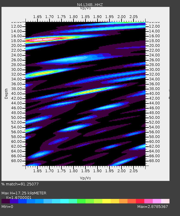
| Estimated Moho Depth: |
17.25 km |
| Estimated Crust Vp/Vs: |
1.67 |
| Assumed Crust Vp: |
6.498 km/s |
| Estimated Crust Vs: |
3.891 km/s |
| Estimated Crust Poisson's Ratio: |
0.22 |
|
| Radial Match: |
91.25077 % |
| Radial Bump: |
400 |
| Transverse Match: |
75.135506 % |
| Transverse Bump: |
400 |
| SOD ConfigId: |
7422571 |
| Insert Time: |
2019-04-19 16:15:02.525 +0000 |
| GWidth: |
2.5 |
| Max Bumps: |
400 |
| Tol: |
0.001 |
|

Signal To Noise
| Channel | StoN | STA | LTA |
| N4:L34B: :HHZ:20150707T05:21:43.22002Z | 35.79169 | 3.4321554E-6 | 9.589252E-8 |
| N4:L34B: :HHN:20150707T05:21:43.22002Z | 15.718825 | 2.0155958E-6 | 1.2822815E-7 |
| N4:L34B: :HHE:20150707T05:21:43.22002Z | 10.949744 | 1.773019E-6 | 1.6192332E-7 |
| Arrivals |
| Ps | 1.8 SECOND |
| PpPs | 6.9 SECOND |
| PsPs/PpSs | 8.7 SECOND |


