You are here: Home > Network List > N4 - Central and EAstern US Network Stations List
> Station M44A Midewin, Midewin Nat. Tallgrass Prarie, IL, USA > Earthquake Result Viewer
M44A Midewin, Midewin Nat. Tallgrass Prarie, IL, USA - Earthquake Result Viewer
| Earthquake location: |
Kuril Islands |
| Earthquake latitude/longitude: |
44.0/147.9 |
| Earthquake time(UTC): |
2015/07/07 (188) 05:10:27 GMT |
| Earthquake Depth: |
38 km |
| Earthquake Magnitude: |
6.3 MO |
| Earthquake Catalog/Contributor: |
NEIC PDE/NEIC ALERT |
|
| Network: |
N4 Central and EAstern US Network |
| Station: |
M44A Midewin, Midewin Nat. Tallgrass Prarie, IL, USA |
| Lat/Lon: |
41.39 N/88.04 W |
| Elevation: |
207 m |
|
| Distance: |
81.3 deg |
| Az: |
39.122 deg |
| Baz: |
322.749 deg |
| Ray Param: |
0.047653906 |
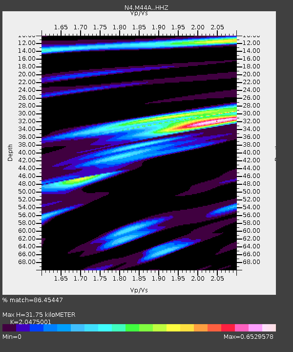
| Estimated Moho Depth: |
31.75 km |
| Estimated Crust Vp/Vs: |
2.05 |
| Assumed Crust Vp: |
6.498 km/s |
| Estimated Crust Vs: |
3.173 km/s |
| Estimated Crust Poisson's Ratio: |
0.34 |
|
| Radial Match: |
86.45447 % |
| Radial Bump: |
383 |
| Transverse Match: |
82.51047 % |
| Transverse Bump: |
354 |
| SOD ConfigId: |
7422571 |
| Insert Time: |
2019-04-19 16:15:07.365 +0000 |
| GWidth: |
2.5 |
| Max Bumps: |
400 |
| Tol: |
0.001 |
|

Signal To Noise
| Channel | StoN | STA | LTA |
| N4:M44A: :HHZ:20150707T05:22:07.330005Z | 25.996609 | 3.4847737E-6 | 1.3404724E-7 |
| N4:M44A: :HHN:20150707T05:22:07.330005Z | 5.305004 | 1.0307812E-6 | 1.9430357E-7 |
| N4:M44A: :HHE:20150707T05:22:07.330005Z | 9.000562 | 9.366514E-7 | 1.0406588E-7 |
| Arrivals |
| Ps | 5.2 SECOND |
| PpPs | 15 SECOND |
| PsPs/PpSs | 20 SECOND |


