You are here: Home > Network List > N4 - Central and EAstern US Network Stations List
> Station M63A Gales Ferry, CT, USA > Earthquake Result Viewer
M63A Gales Ferry, CT, USA - Earthquake Result Viewer
| Earthquake location: |
Kuril Islands |
| Earthquake latitude/longitude: |
44.0/147.9 |
| Earthquake time(UTC): |
2015/07/07 (188) 05:10:27 GMT |
| Earthquake Depth: |
38 km |
| Earthquake Magnitude: |
6.3 MO |
| Earthquake Catalog/Contributor: |
NEIC PDE/NEIC ALERT |
|
| Network: |
N4 Central and EAstern US Network |
| Station: |
M63A Gales Ferry, CT, USA |
| Lat/Lon: |
41.40 N/72.05 W |
| Elevation: |
44 m |
|
| Distance: |
87.7 deg |
| Az: |
28.931 deg |
| Baz: |
332.342 deg |
| Ray Param: |
0.04307048 |
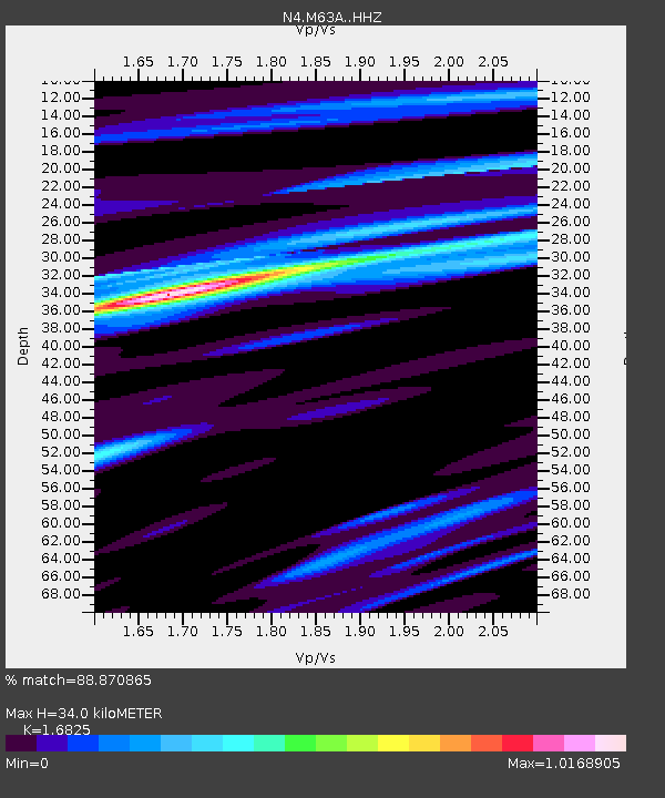
| Estimated Moho Depth: |
34.0 km |
| Estimated Crust Vp/Vs: |
1.68 |
| Assumed Crust Vp: |
6.472 km/s |
| Estimated Crust Vs: |
3.847 km/s |
| Estimated Crust Poisson's Ratio: |
0.23 |
|
| Radial Match: |
88.870865 % |
| Radial Bump: |
255 |
| Transverse Match: |
77.320114 % |
| Transverse Bump: |
343 |
| SOD ConfigId: |
7422571 |
| Insert Time: |
2019-04-19 16:15:10.752 +0000 |
| GWidth: |
2.5 |
| Max Bumps: |
400 |
| Tol: |
0.001 |
|

Signal To Noise
| Channel | StoN | STA | LTA |
| N4:M63A: :HHZ:20150707T05:22:39.850024Z | 11.047088 | 2.9777736E-6 | 2.6955283E-7 |
| N4:M63A: :HHN:20150707T05:22:39.850024Z | 4.996874 | 8.606759E-7 | 1.7224288E-7 |
| N4:M63A: :HHE:20150707T05:22:39.850024Z | 5.4982634 | 7.805287E-7 | 1.4195913E-7 |
| Arrivals |
| Ps | 3.7 SECOND |
| PpPs | 14 SECOND |
| PsPs/PpSs | 17 SECOND |


