You are here: Home > Network List > N4 - Central and EAstern US Network Stations List
> Station V53A Sandy Mush, NC, USA > Earthquake Result Viewer
V53A Sandy Mush, NC, USA - Earthquake Result Viewer
| Earthquake location: |
Kuril Islands |
| Earthquake latitude/longitude: |
44.0/147.9 |
| Earthquake time(UTC): |
2015/07/07 (188) 05:10:27 GMT |
| Earthquake Depth: |
38 km |
| Earthquake Magnitude: |
6.3 MO |
| Earthquake Catalog/Contributor: |
NEIC PDE/NEIC ALERT |
|
| Network: |
N4 Central and EAstern US Network |
| Station: |
V53A Sandy Mush, NC, USA |
| Lat/Lon: |
35.67 N/82.81 W |
| Elevation: |
681 m |
|
| Distance: |
88.3 deg |
| Az: |
39.11 deg |
| Baz: |
325.998 deg |
| Ray Param: |
0.042644005 |
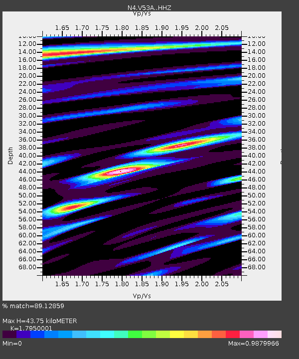
| Estimated Moho Depth: |
43.75 km |
| Estimated Crust Vp/Vs: |
1.80 |
| Assumed Crust Vp: |
6.35 km/s |
| Estimated Crust Vs: |
3.538 km/s |
| Estimated Crust Poisson's Ratio: |
0.27 |
|
| Radial Match: |
89.12859 % |
| Radial Bump: |
319 |
| Transverse Match: |
78.66474 % |
| Transverse Bump: |
400 |
| SOD ConfigId: |
7422571 |
| Insert Time: |
2019-04-19 16:15:58.349 +0000 |
| GWidth: |
2.5 |
| Max Bumps: |
400 |
| Tol: |
0.001 |
|

Signal To Noise
| Channel | StoN | STA | LTA |
| N4:V53A: :HHZ:20150707T05:22:42.540027Z | 38.460663 | 2.3118114E-6 | 6.010847E-8 |
| N4:V53A: :HHN:20150707T05:22:42.540027Z | 8.501552 | 5.4111365E-7 | 6.364881E-8 |
| N4:V53A: :HHE:20150707T05:22:42.540027Z | 4.4933705 | 3.638279E-7 | 8.0969926E-8 |
| Arrivals |
| Ps | 5.6 SECOND |
| PpPs | 19 SECOND |
| PsPs/PpSs | 24 SECOND |


