You are here: Home > Network List > NM - Cooperative New Madrid Seismic Network Stations List
> Station MGMO Mountain Grove, MO > Earthquake Result Viewer
MGMO Mountain Grove, MO - Earthquake Result Viewer
| Earthquake location: |
Kuril Islands |
| Earthquake latitude/longitude: |
44.0/147.9 |
| Earthquake time(UTC): |
2015/07/07 (188) 05:10:27 GMT |
| Earthquake Depth: |
38 km |
| Earthquake Magnitude: |
6.3 MO |
| Earthquake Catalog/Contributor: |
NEIC PDE/NEIC ALERT |
|
| Network: |
NM Cooperative New Madrid Seismic Network |
| Station: |
MGMO Mountain Grove, MO |
| Lat/Lon: |
37.15 N/92.27 W |
| Elevation: |
453 m |
|
| Distance: |
82.6 deg |
| Az: |
44.366 deg |
| Baz: |
320.821 deg |
| Ray Param: |
0.046752185 |
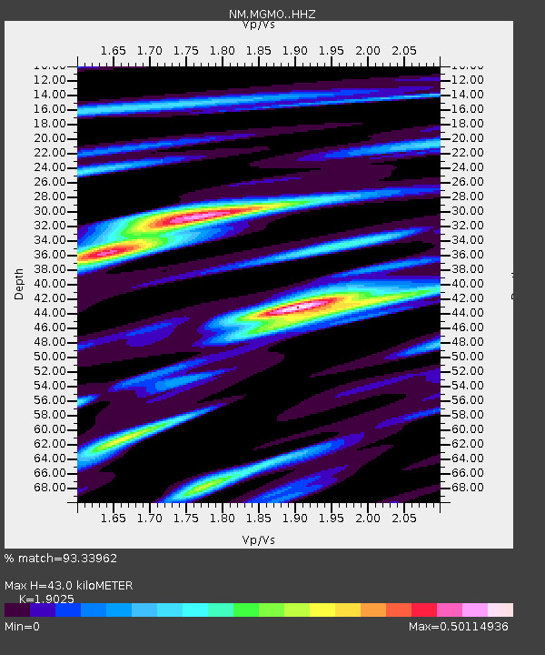
| Estimated Moho Depth: |
43.0 km |
| Estimated Crust Vp/Vs: |
1.90 |
| Assumed Crust Vp: |
6.53 km/s |
| Estimated Crust Vs: |
3.433 km/s |
| Estimated Crust Poisson's Ratio: |
0.31 |
|
| Radial Match: |
93.33962 % |
| Radial Bump: |
346 |
| Transverse Match: |
83.25317 % |
| Transverse Bump: |
400 |
| SOD ConfigId: |
7422571 |
| Insert Time: |
2019-04-19 16:16:28.903 +0000 |
| GWidth: |
2.5 |
| Max Bumps: |
400 |
| Tol: |
0.001 |
|

Signal To Noise
| Channel | StoN | STA | LTA |
| NM:MGMO: :HHZ:20150707T05:22:14.067981Z | 55.230843 | 2.6728742E-6 | 4.8394593E-8 |
| NM:MGMO: :HHN:20150707T05:22:14.067981Z | 9.859222 | 9.653735E-7 | 9.791578E-8 |
| NM:MGMO: :HHE:20150707T05:22:14.067981Z | 13.044849 | 6.2824387E-7 | 4.81603E-8 |
| Arrivals |
| Ps | 6.1 SECOND |
| PpPs | 19 SECOND |
| PsPs/PpSs | 25 SECOND |


