You are here: Home > Network List > NM - Cooperative New Madrid Seismic Network Stations List
> Station PVMO UM Delta Research Portageville, MO > Earthquake Result Viewer
PVMO UM Delta Research Portageville, MO - Earthquake Result Viewer
| Earthquake location: |
Kuril Islands |
| Earthquake latitude/longitude: |
44.0/147.9 |
| Earthquake time(UTC): |
2015/07/07 (188) 05:10:27 GMT |
| Earthquake Depth: |
38 km |
| Earthquake Magnitude: |
6.3 MO |
| Earthquake Catalog/Contributor: |
NEIC PDE/NEIC ALERT |
|
| Network: |
NM Cooperative New Madrid Seismic Network |
| Station: |
PVMO UM Delta Research Portageville, MO |
| Lat/Lon: |
36.41 N/89.70 W |
| Elevation: |
98 m |
|
| Distance: |
84.4 deg |
| Az: |
43.204 deg |
| Baz: |
322.221 deg |
| Ray Param: |
0.045444507 |
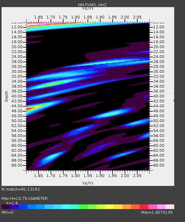
| Estimated Moho Depth: |
10.75 km |
| Estimated Crust Vp/Vs: |
1.60 |
| Assumed Crust Vp: |
6.444 km/s |
| Estimated Crust Vs: |
4.027 km/s |
| Estimated Crust Poisson's Ratio: |
0.18 |
|
| Radial Match: |
91.13192 % |
| Radial Bump: |
400 |
| Transverse Match: |
81.91399 % |
| Transverse Bump: |
400 |
| SOD ConfigId: |
7422571 |
| Insert Time: |
2019-04-19 16:16:29.422 +0000 |
| GWidth: |
2.5 |
| Max Bumps: |
400 |
| Tol: |
0.001 |
|

Signal To Noise
| Channel | StoN | STA | LTA |
| NM:PVMO: :HHZ:20150707T05:22:23.588977Z | 7.2305284 | 4.32449E-6 | 5.980877E-7 |
| NM:PVMO: :HHN:20150707T05:22:23.588977Z | 3.0209403 | 2.1907165E-6 | 7.25177E-7 |
| NM:PVMO: :HHE:20150707T05:22:23.588977Z | 4.9632134 | 2.7569033E-6 | 5.554674E-7 |
| Arrivals |
| Ps | 1.0 SECOND |
| PpPs | 4.2 SECOND |
| PsPs/PpSs | 5.2 SECOND |


