You are here: Home > Network List > NN - Western Great Basin/Eastern Sierra Nevada Stations List
> Station KVN Kaiserville, Nevada w84gm > Earthquake Result Viewer
KVN Kaiserville, Nevada w84gm - Earthquake Result Viewer
| Earthquake location: |
Kuril Islands |
| Earthquake latitude/longitude: |
44.0/147.9 |
| Earthquake time(UTC): |
2015/07/07 (188) 05:10:27 GMT |
| Earthquake Depth: |
38 km |
| Earthquake Magnitude: |
6.3 MO |
| Earthquake Catalog/Contributor: |
NEIC PDE/NEIC ALERT |
|
| Network: |
NN Western Great Basin/Eastern Sierra Nevada |
| Station: |
KVN Kaiserville, Nevada w84gm |
| Lat/Lon: |
39.05 N/118.10 W |
| Elevation: |
1829 m |
|
| Distance: |
66.7 deg |
| Az: |
57.75 deg |
| Baz: |
308.373 deg |
| Ray Param: |
0.057367794 |
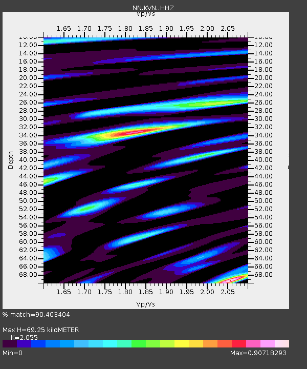
| Estimated Moho Depth: |
69.25 km |
| Estimated Crust Vp/Vs: |
2.06 |
| Assumed Crust Vp: |
6.279 km/s |
| Estimated Crust Vs: |
3.055 km/s |
| Estimated Crust Poisson's Ratio: |
0.34 |
|
| Radial Match: |
90.403404 % |
| Radial Bump: |
396 |
| Transverse Match: |
81.65527 % |
| Transverse Bump: |
392 |
| SOD ConfigId: |
7422571 |
| Insert Time: |
2019-04-19 16:16:36.293 +0000 |
| GWidth: |
2.5 |
| Max Bumps: |
400 |
| Tol: |
0.001 |
|

Signal To Noise
| Channel | StoN | STA | LTA |
| NN:KVN: :HHZ:20150707T05:20:42.544971Z | 39.042084 | 2.185396E-6 | 5.597539E-8 |
| NN:KVN: :HHN:20150707T05:20:42.544971Z | 11.181861 | 4.634893E-7 | 4.1450104E-8 |
| NN:KVN: :HHE:20150707T05:20:42.544971Z | 9.8372555 | 6.4886547E-7 | 6.596001E-8 |
| Arrivals |
| Ps | 12 SECOND |
| PpPs | 33 SECOND |
| PsPs/PpSs | 45 SECOND |


