You are here: Home > Network List > NX - Nanometrics Research Network Stations List
> Station STN21 Seismic station 21 > Earthquake Result Viewer
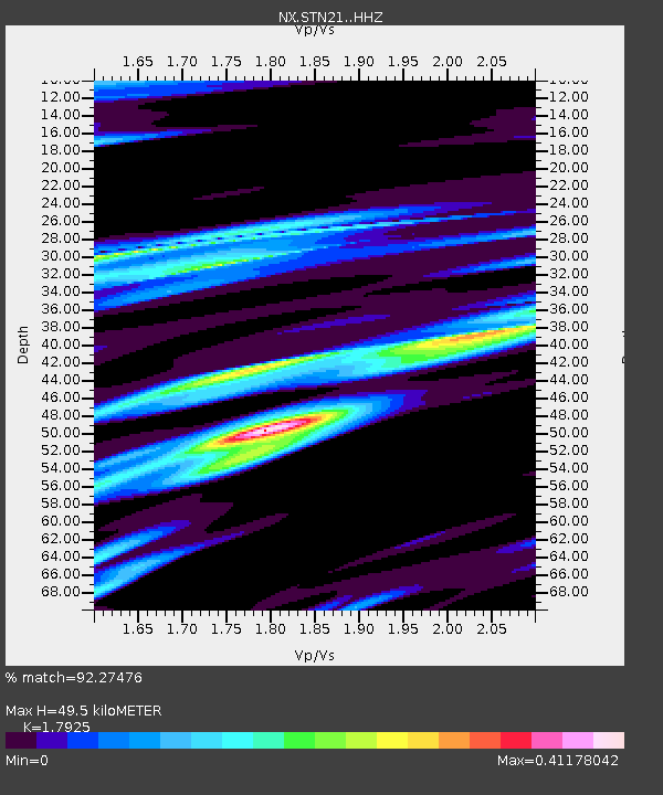
STN21 Seismic station 21 - Earthquake Result Viewer
| Earthquake location: |
Kuril Islands |
| Earthquake latitude/longitude: |
44.0/147.9 |
| Earthquake time(UTC): |
2015/07/07 (188) 05:10:27 GMT |
| Earthquake Depth: |
38 km |
| Earthquake Magnitude: |
6.3 MO |
| Earthquake Catalog/Contributor: |
NEIC PDE/NEIC ALERT |
|
| Network: |
NX Nanometrics Research Network |
| Station: |
STN21 Seismic station 21 |
| Lat/Lon: |
36.75 N/97.56 W |
| Elevation: |
333 m |
|
| Distance: |
80.1 deg |
| Az: |
47.89 deg |
| Baz: |
318.183 deg |
| Ray Param: |
0.04844822 |
| Estimated Moho Depth: |
49.5 km |
| Estimated Crust Vp/Vs: |
1.79 |
| Assumed Crust Vp: |
6.483 km/s |
| Estimated Crust Vs: |
3.617 km/s |
| Estimated Crust Poisson's Ratio: |
0.27 |
|
| Radial Match: |
92.27476 % |
| Radial Bump: |
277 |
| Transverse Match: |
73.834755 % |
| Transverse Bump: |
400 |
| SOD ConfigId: |
7422571 |
| Insert Time: |
2019-04-19 16:17:06.036 +0000 |
| GWidth: |
2.5 |
| Max Bumps: |
400 |
| Tol: |
0.001 |
|

Signal To Noise
| Channel | StoN | STA | LTA |
| NX:STN21: :HHZ:20150707T05:22:01.129993Z | 44.548702 | 2.987887E-6 | 6.7070125E-8 |
| NX:STN21: :HH1:20150707T05:22:01.129993Z | 7.432071 | 1.2559066E-6 | 1.6898474E-7 |
| NX:STN21: :HH2:20150707T05:22:01.129993Z | 6.9457784 | 8.132264E-7 | 1.1708211E-7 |
| Arrivals |
| Ps | 6.2 SECOND |
| PpPs | 21 SECOND |
| PsPs/PpSs | 27 SECOND |


