You are here: Home > Network List > NX - Nanometrics Research Network Stations List
> Station STN26 Seismic station 25 > Earthquake Result Viewer
STN26 Seismic station 25 - Earthquake Result Viewer
| Earthquake location: |
Kuril Islands |
| Earthquake latitude/longitude: |
44.0/147.9 |
| Earthquake time(UTC): |
2015/07/07 (188) 05:10:27 GMT |
| Earthquake Depth: |
38 km |
| Earthquake Magnitude: |
6.3 MO |
| Earthquake Catalog/Contributor: |
NEIC PDE/NEIC ALERT |
|
| Network: |
NX Nanometrics Research Network |
| Station: |
STN26 Seismic station 25 |
| Lat/Lon: |
36.93 N/97.21 W |
| Elevation: |
353 m |
|
| Distance: |
80.2 deg |
| Az: |
47.558 deg |
| Baz: |
318.337 deg |
| Ray Param: |
0.04840773 |
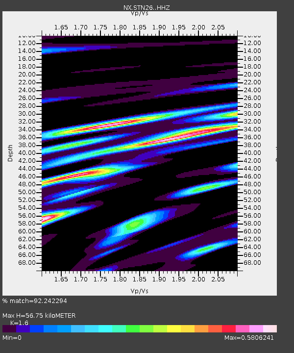
| Estimated Moho Depth: |
56.75 km |
| Estimated Crust Vp/Vs: |
1.60 |
| Assumed Crust Vp: |
6.483 km/s |
| Estimated Crust Vs: |
4.052 km/s |
| Estimated Crust Poisson's Ratio: |
0.18 |
|
| Radial Match: |
92.242294 % |
| Radial Bump: |
385 |
| Transverse Match: |
82.98639 % |
| Transverse Bump: |
400 |
| SOD ConfigId: |
7422571 |
| Insert Time: |
2019-04-19 16:17:09.453 +0000 |
| GWidth: |
2.5 |
| Max Bumps: |
400 |
| Tol: |
0.001 |
|

Signal To Noise
| Channel | StoN | STA | LTA |
| NX:STN26: :HHZ:20150707T05:22:01.450Z | 27.727156 | 2.604659E-6 | 9.3938915E-8 |
| NX:STN26: :HH1:20150707T05:22:01.450Z | 13.734581 | 1.2968159E-6 | 9.4419754E-8 |
| NX:STN26: :HH2:20150707T05:22:01.450Z | 1.1156983 | 9.7708536E-8 | 8.7576126E-8 |
| Arrivals |
| Ps | 5.4 SECOND |
| PpPs | 22 SECOND |
| PsPs/PpSs | 27 SECOND |


