You are here: Home > Network List > NX - Nanometrics Research Network Stations List
> Station STN31 Seismic station 26 > Earthquake Result Viewer
STN31 Seismic station 26 - Earthquake Result Viewer
| Earthquake location: |
Kuril Islands |
| Earthquake latitude/longitude: |
44.0/147.9 |
| Earthquake time(UTC): |
2015/07/07 (188) 05:10:27 GMT |
| Earthquake Depth: |
38 km |
| Earthquake Magnitude: |
6.3 MO |
| Earthquake Catalog/Contributor: |
NEIC PDE/NEIC ALERT |
|
| Network: |
NX Nanometrics Research Network |
| Station: |
STN31 Seismic station 26 |
| Lat/Lon: |
35.76 N/97.44 W |
| Elevation: |
329 m |
|
| Distance: |
80.9 deg |
| Az: |
48.488 deg |
| Baz: |
318.351 deg |
| Ray Param: |
0.047901668 |
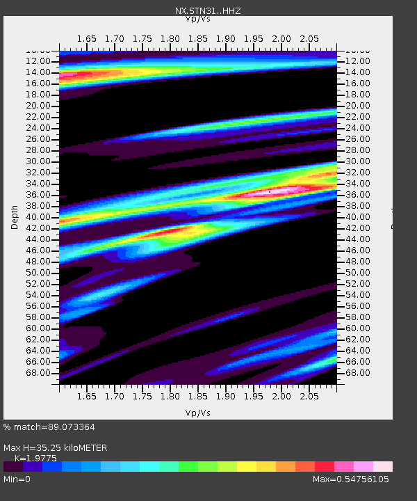
| Estimated Moho Depth: |
35.25 km |
| Estimated Crust Vp/Vs: |
1.98 |
| Assumed Crust Vp: |
6.426 km/s |
| Estimated Crust Vs: |
3.25 km/s |
| Estimated Crust Poisson's Ratio: |
0.33 |
|
| Radial Match: |
89.073364 % |
| Radial Bump: |
311 |
| Transverse Match: |
86.96642 % |
| Transverse Bump: |
383 |
| SOD ConfigId: |
7422571 |
| Insert Time: |
2019-04-19 16:17:10.113 +0000 |
| GWidth: |
2.5 |
| Max Bumps: |
400 |
| Tol: |
0.001 |
|

Signal To Noise
| Channel | StoN | STA | LTA |
| NX:STN31: :HHZ:20150707T05:22:05.419971Z | 27.264404 | 3.3322779E-6 | 1.2222081E-7 |
| NX:STN31: :HH1:20150707T05:22:05.419971Z | 1.9378543 | 3.1063712E-7 | 1.6029954E-7 |
| NX:STN31: :HH2:20150707T05:22:05.419971Z | 12.78562 | 1.1286282E-6 | 8.8273254E-8 |
| Arrivals |
| Ps | 5.5 SECOND |
| PpPs | 16 SECOND |
| PsPs/PpSs | 21 SECOND |


