You are here: Home > Network List > NY - Yukon Northwest Seismic Network(YNSN) Stations List
> Station WTLY Watson Lake, Yukon, CANADA > Earthquake Result Viewer
WTLY Watson Lake, Yukon, CANADA - Earthquake Result Viewer
| Earthquake location: |
Kuril Islands |
| Earthquake latitude/longitude: |
44.0/147.9 |
| Earthquake time(UTC): |
2015/07/07 (188) 05:10:27 GMT |
| Earthquake Depth: |
38 km |
| Earthquake Magnitude: |
6.3 MO |
| Earthquake Catalog/Contributor: |
NEIC PDE/NEIC ALERT |
|
| Network: |
NY Yukon Northwest Seismic Network(YNSN) |
| Station: |
WTLY Watson Lake, Yukon, CANADA |
| Lat/Lon: |
60.11 N/128.80 W |
| Elevation: |
0.0 m |
|
| Distance: |
50.1 deg |
| Az: |
40.411 deg |
| Baz: |
290.872 deg |
| Ray Param: |
0.06819727 |
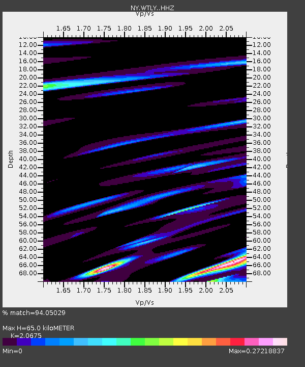
| Estimated Moho Depth: |
65.0 km |
| Estimated Crust Vp/Vs: |
2.07 |
| Assumed Crust Vp: |
6.35 km/s |
| Estimated Crust Vs: |
3.071 km/s |
| Estimated Crust Poisson's Ratio: |
0.35 |
|
| Radial Match: |
94.05029 % |
| Radial Bump: |
290 |
| Transverse Match: |
75.368454 % |
| Transverse Bump: |
400 |
| SOD ConfigId: |
7422571 |
| Insert Time: |
2019-04-19 16:17:22.113 +0000 |
| GWidth: |
2.5 |
| Max Bumps: |
400 |
| Tol: |
0.001 |
|

Signal To Noise
| Channel | StoN | STA | LTA |
| NY:WTLY: :HHZ:20150707T05:18:47.120013Z | 25.507473 | 2.427087E-6 | 9.5152004E-8 |
| NY:WTLY: :HHN:20150707T05:18:47.120013Z | 4.5643215 | 5.2688455E-7 | 1.15435455E-7 |
| NY:WTLY: :HHE:20150707T05:18:47.120013Z | 24.437471 | 2.9790244E-6 | 1.2190395E-7 |
| Arrivals |
| Ps | 11 SECOND |
| PpPs | 30 SECOND |
| PsPs/PpSs | 41 SECOND |


