You are here: Home > Network List > PE - Penn State Network Stations List
> Station PSWB Penn State Wilkes-Barre > Earthquake Result Viewer
PSWB Penn State Wilkes-Barre - Earthquake Result Viewer
| Earthquake location: |
Kuril Islands |
| Earthquake latitude/longitude: |
44.0/147.9 |
| Earthquake time(UTC): |
2015/07/07 (188) 05:10:27 GMT |
| Earthquake Depth: |
38 km |
| Earthquake Magnitude: |
6.3 MO |
| Earthquake Catalog/Contributor: |
NEIC PDE/NEIC ALERT |
|
| Network: |
PE Penn State Network |
| Station: |
PSWB Penn State Wilkes-Barre |
| Lat/Lon: |
41.31 N/76.02 W |
| Elevation: |
398 m |
|
| Distance: |
86.4 deg |
| Az: |
31.598 deg |
| Baz: |
329.867 deg |
| Ray Param: |
0.044056997 |
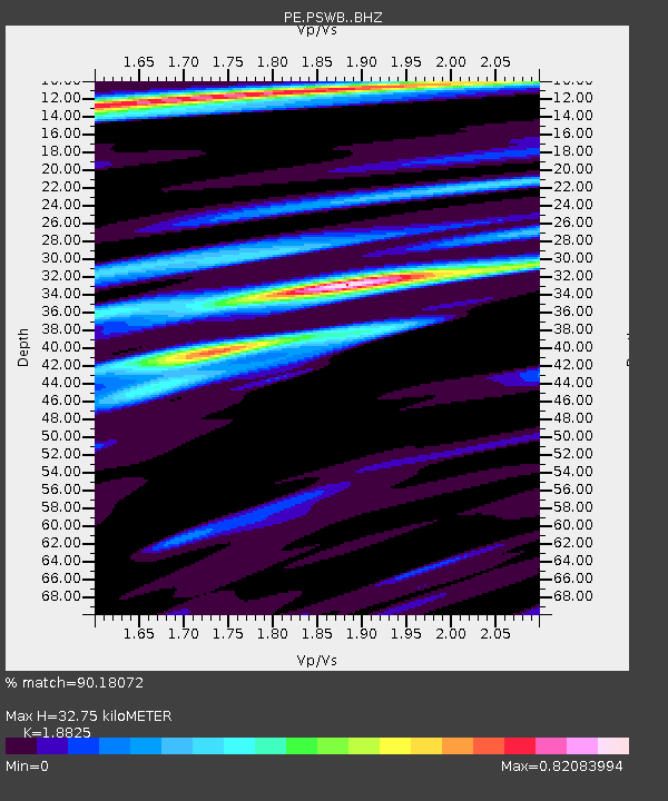
| Estimated Moho Depth: |
32.75 km |
| Estimated Crust Vp/Vs: |
1.88 |
| Assumed Crust Vp: |
6.121 km/s |
| Estimated Crust Vs: |
3.251 km/s |
| Estimated Crust Poisson's Ratio: |
0.30 |
|
| Radial Match: |
90.18072 % |
| Radial Bump: |
322 |
| Transverse Match: |
76.46264 % |
| Transverse Bump: |
400 |
| SOD ConfigId: |
7422571 |
| Insert Time: |
2019-04-19 16:17:37.231 +0000 |
| GWidth: |
2.5 |
| Max Bumps: |
400 |
| Tol: |
0.001 |
|

Signal To Noise
| Channel | StoN | STA | LTA |
| PE:PSWB: :BHZ:20150707T05:22:33.280017Z | 34.587296 | 4.062092E-6 | 1.1744463E-7 |
| PE:PSWB: :BHN:20150707T05:22:33.280017Z | 11.016378 | 9.905071E-7 | 8.9912234E-8 |
| PE:PSWB: :BHE:20150707T05:22:33.280017Z | 10.981802 | 9.474981E-7 | 8.6278924E-8 |
| Arrivals |
| Ps | 4.8 SECOND |
| PpPs | 15 SECOND |
| PsPs/PpSs | 20 SECOND |


