You are here: Home > Network List > RV - Regional Alberta Seismic Observatory for Earthquake Studies Network Stations List
> Station ATHA Athabasca, AB > Earthquake Result Viewer
ATHA Athabasca, AB - Earthquake Result Viewer
| Earthquake location: |
Kuril Islands |
| Earthquake latitude/longitude: |
44.0/147.9 |
| Earthquake time(UTC): |
2015/07/07 (188) 05:10:27 GMT |
| Earthquake Depth: |
38 km |
| Earthquake Magnitude: |
6.3 MO |
| Earthquake Catalog/Contributor: |
NEIC PDE/NEIC ALERT |
|
| Network: |
RV Regional Alberta Seismic Observatory for Earthquake Studies Network |
| Station: |
ATHA Athabasca, AB |
| Lat/Lon: |
54.71 N/113.31 W |
| Elevation: |
569 m |
|
| Distance: |
60.0 deg |
| Az: |
41.467 deg |
| Baz: |
304.536 deg |
| Ray Param: |
0.061744962 |
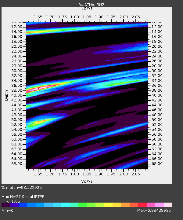
| Estimated Moho Depth: |
37.0 km |
| Estimated Crust Vp/Vs: |
1.65 |
| Assumed Crust Vp: |
6.444 km/s |
| Estimated Crust Vs: |
3.905 km/s |
| Estimated Crust Poisson's Ratio: |
0.21 |
|
| Radial Match: |
93.122925 % |
| Radial Bump: |
320 |
| Transverse Match: |
86.26118 % |
| Transverse Bump: |
400 |
| SOD ConfigId: |
7422571 |
| Insert Time: |
2019-04-19 16:18:08.796 +0000 |
| GWidth: |
2.5 |
| Max Bumps: |
400 |
| Tol: |
0.001 |
|

Signal To Noise
| Channel | StoN | STA | LTA |
| RV:ATHA: :BHZ:20150707T05:19:58.390002Z | 28.294964 | 5.0238045E-6 | 1.775512E-7 |
| RV:ATHA: :BHN:20150707T05:19:58.390002Z | 6.2580004 | 1.8807893E-6 | 3.005416E-7 |
| RV:ATHA: :BHE:20150707T05:19:58.390002Z | 18.565441 | 3.060793E-6 | 1.6486509E-7 |
| Arrivals |
| Ps | 3.9 SECOND |
| PpPs | 14 SECOND |
| PsPs/PpSs | 18 SECOND |


