You are here: Home > Network List > IU - Global Seismograph Network (GSN - IRIS/USGS) Stations List
> Station ULN Ulaanbaatar, Mongolia > Earthquake Result Viewer
ULN Ulaanbaatar, Mongolia - Earthquake Result Viewer
| Earthquake location: |
Timor Region |
| Earthquake latitude/longitude: |
-8.2/124.9 |
| Earthquake time(UTC): |
2004/11/11 (316) 21:26:41 GMT |
| Earthquake Depth: |
10 km |
| Earthquake Magnitude: |
6.5 MB, 7.3 MS, 7.5 MW, 7.4 MW |
| Earthquake Catalog/Contributor: |
WHDF/NEIC |
|
| Network: |
IU Global Seismograph Network (GSN - IRIS/USGS) |
| Station: |
ULN Ulaanbaatar, Mongolia |
| Lat/Lon: |
47.87 N/107.05 E |
| Elevation: |
1610 m |
|
| Distance: |
58.0 deg |
| Az: |
345.935 deg |
| Baz: |
159.064 deg |
| Ray Param: |
0.063156724 |
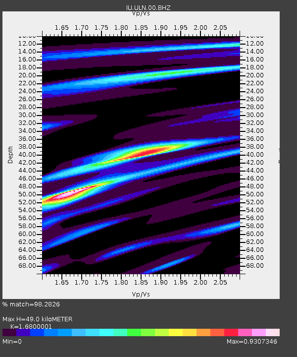
| Estimated Moho Depth: |
49.0 km |
| Estimated Crust Vp/Vs: |
1.68 |
| Assumed Crust Vp: |
6.642 km/s |
| Estimated Crust Vs: |
3.953 km/s |
| Estimated Crust Poisson's Ratio: |
0.23 |
|
| Radial Match: |
98.2826 % |
| Radial Bump: |
318 |
| Transverse Match: |
90.03121 % |
| Transverse Bump: |
400 |
| SOD ConfigId: |
2459 |
| Insert Time: |
2010-03-03 15:54:05.540 +0000 |
| GWidth: |
2.5 |
| Max Bumps: |
400 |
| Tol: |
0.001 |
|
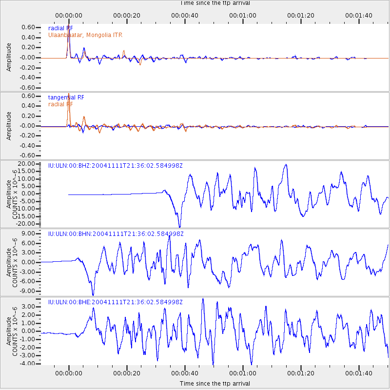
Signal To Noise
| Channel | StoN | STA | LTA |
| IU:ULN:00:BHN:20041111T21:36:02.584998Z | 5.783204 | 7.429299E-7 | 1.2846338E-7 |
| IU:ULN:00:BHE:20041111T21:36:02.584998Z | 5.079238 | 2.7105062E-7 | 5.3364428E-8 |
| IU:ULN:00:BHZ:20041111T21:36:02.584998Z | 5.547421 | 1.3385767E-6 | 2.412971E-7 |
| Arrivals |
| Ps | 5.3 SECOND |
| PpPs | 19 SECOND |
| PsPs/PpSs | 24 SECOND |


