You are here: Home > Network List > TA - USArray Transportable Network (new EarthScope stations) Stations List
> Station C36M Paulatuk, NT, CAN > Earthquake Result Viewer
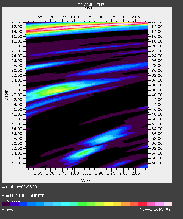
C36M Paulatuk, NT, CAN - Earthquake Result Viewer
| Earthquake location: |
Kuril Islands |
| Earthquake latitude/longitude: |
44.0/147.9 |
| Earthquake time(UTC): |
2015/07/07 (188) 05:10:27 GMT |
| Earthquake Depth: |
38 km |
| Earthquake Magnitude: |
6.3 MO |
| Earthquake Catalog/Contributor: |
NEIC PDE/NEIC ALERT |
|
| Network: |
TA USArray Transportable Network (new EarthScope stations) |
| Station: |
C36M Paulatuk, NT, CAN |
| Lat/Lon: |
69.35 N/124.07 W |
| Elevation: |
10 m |
|
| Distance: |
49.0 deg |
| Az: |
28.019 deg |
| Baz: |
287.098 deg |
| Ray Param: |
0.06889933 |
| Estimated Moho Depth: |
11.5 km |
| Estimated Crust Vp/Vs: |
1.85 |
| Assumed Crust Vp: |
6.459 km/s |
| Estimated Crust Vs: |
3.492 km/s |
| Estimated Crust Poisson's Ratio: |
0.29 |
|
| Radial Match: |
92.6346 % |
| Radial Bump: |
400 |
| Transverse Match: |
87.44835 % |
| Transverse Bump: |
400 |
| SOD ConfigId: |
7422571 |
| Insert Time: |
2019-04-19 16:18:42.721 +0000 |
| GWidth: |
2.5 |
| Max Bumps: |
400 |
| Tol: |
0.001 |
|

Signal To Noise
| Channel | StoN | STA | LTA |
| TA:C36M: :BHZ:20150707T05:18:38.848987Z | 92.38894 | 1.676227E-5 | 1.8143156E-7 |
| TA:C36M: :BHN:20150707T05:18:38.848987Z | 6.9400845 | 1.0058603E-6 | 1.4493487E-7 |
| TA:C36M: :BHE:20150707T05:18:38.848987Z | 57.98969 | 4.4588464E-6 | 7.689033E-8 |
| Arrivals |
| Ps | 1.6 SECOND |
| PpPs | 4.8 SECOND |
| PsPs/PpSs | 6.4 SECOND |


