You are here: Home > Network List > TA - USArray Transportable Network (new EarthScope stations) Stations List
> Station D58A Chemin du LacGrosbois, Trois-Rives, QC, CAN > Earthquake Result Viewer
D58A Chemin du LacGrosbois, Trois-Rives, QC, CAN - Earthquake Result Viewer
| Earthquake location: |
Kuril Islands |
| Earthquake latitude/longitude: |
44.0/147.9 |
| Earthquake time(UTC): |
2015/07/07 (188) 05:10:27 GMT |
| Earthquake Depth: |
38 km |
| Earthquake Magnitude: |
6.3 MO |
| Earthquake Catalog/Contributor: |
NEIC PDE/NEIC ALERT |
|
| Network: |
TA USArray Transportable Network (new EarthScope stations) |
| Station: |
D58A Chemin du LacGrosbois, Trois-Rives, QC, CAN |
| Lat/Lon: |
47.10 N/72.88 W |
| Elevation: |
398 m |
|
| Distance: |
82.4 deg |
| Az: |
26.779 deg |
| Baz: |
331.575 deg |
| Ray Param: |
0.04685221 |
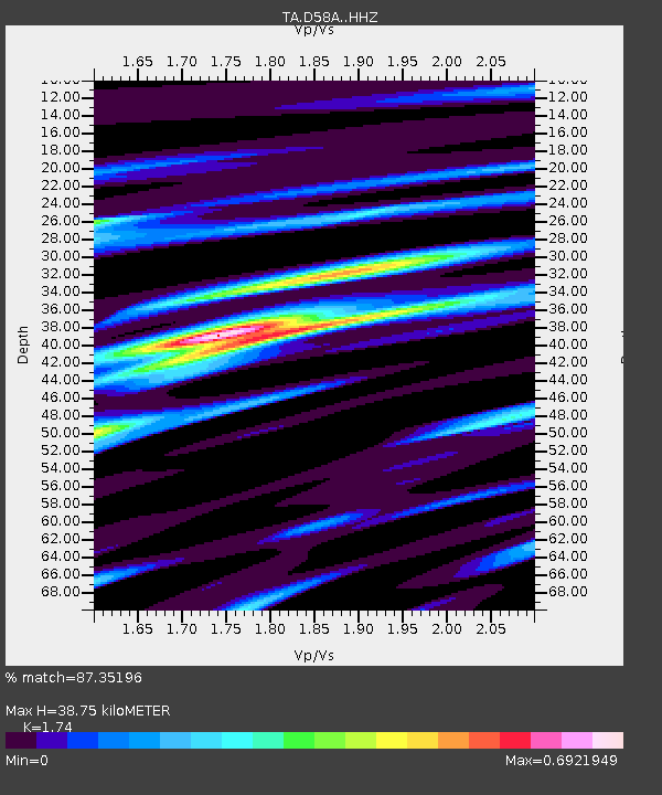
| Estimated Moho Depth: |
38.75 km |
| Estimated Crust Vp/Vs: |
1.74 |
| Assumed Crust Vp: |
6.61 km/s |
| Estimated Crust Vs: |
3.799 km/s |
| Estimated Crust Poisson's Ratio: |
0.25 |
|
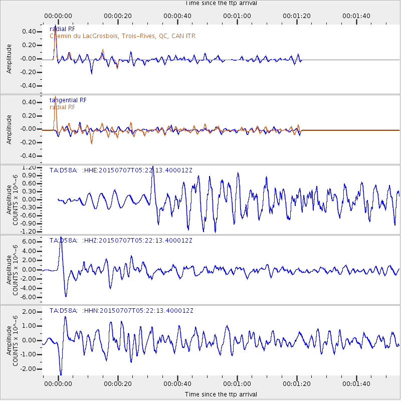
| Radial Match: |
87.35196 % |
| Radial Bump: |
228 |
| Transverse Match: |
71.143486 % |
| Transverse Bump: |
347 |
| SOD ConfigId: |
7422571 |
| Insert Time: |
2019-04-19 16:18:43.423 +0000 |
| GWidth: |
2.5 |
| Max Bumps: |
400 |
| Tol: |
0.001 |
|
Signal To Noise
| Channel | StoN | STA | LTA |
| TA:D58A: :HHZ:20150707T05:22:13.400012Z | 15.714174 | 3.3875187E-6 | 2.155709E-7 |
| TA:D58A: :HHN:20150707T05:22:13.400012Z | 8.947245 | 1.0609293E-6 | 1.1857609E-7 |
| TA:D58A: :HHE:20150707T05:22:13.400012Z | 3.278305 | 5.4851785E-7 | 1.6731751E-7 |
| Arrivals |
| Ps | 4.5 SECOND |
| PpPs | 16 SECOND |
| PsPs/PpSs | 20 SECOND |


