You are here: Home > Network List > TA - USArray Transportable Network (new EarthScope stations) Stations List
> Station E63A Oxbow, ME, USA > Earthquake Result Viewer
E63A Oxbow, ME, USA - Earthquake Result Viewer
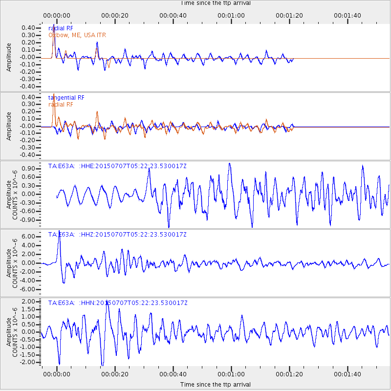
| Earthquake location: |
Kuril Islands |
| Earthquake latitude/longitude: |
44.0/147.9 |
| Earthquake time(UTC): |
2015/07/07 (188) 05:10:27 GMT |
| Earthquake Depth: |
38 km |
| Earthquake Magnitude: |
6.3 MO |
| Earthquake Catalog/Contributor: |
NEIC PDE/NEIC ALERT |
|
| Network: |
TA USArray Transportable Network (new EarthScope stations) |
| Station: |
E63A Oxbow, ME, USA |
| Lat/Lon: |
46.42 N/68.42 W |
| Elevation: |
238 m |
|
| Distance: |
84.4 deg |
| Az: |
24.335 deg |
| Baz: |
334.534 deg |
| Ray Param: |
0.045455936 |
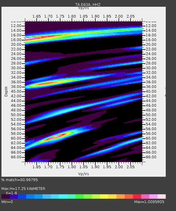
| Estimated Moho Depth: |
17.25 km |
| Estimated Crust Vp/Vs: |
1.60 |
| Assumed Crust Vp: |
6.419 km/s |
| Estimated Crust Vs: |
4.012 km/s |
| Estimated Crust Poisson's Ratio: |
0.18 |
|
| Radial Match: |
80.99795 % |
| Radial Bump: |
317 |
| Transverse Match: |
61.020256 % |
| Transverse Bump: |
350 |
| SOD ConfigId: |
7422571 |
| Insert Time: |
2019-04-19 16:18:53.501 +0000 |
| GWidth: |
2.5 |
| Max Bumps: |
400 |
| Tol: |
0.001 |
|
Signal To Noise
| Channel | StoN | STA | LTA |
| TA:E63A: :HHZ:20150707T05:22:23.530017Z | 12.95972 | 2.983364E-6 | 2.3020282E-7 |
| TA:E63A: :HHN:20150707T05:22:23.530017Z | 4.409785 | 7.947812E-7 | 1.802313E-7 |
| TA:E63A: :HHE:20150707T05:22:23.530017Z | 2.0589285 | 4.269726E-7 | 2.073761E-7 |
| Arrivals |
| Ps | 1.7 SECOND |
| PpPs | 6.8 SECOND |
| PsPs/PpSs | 8.5 SECOND |


