You are here: Home > Network List > TA - USArray Transportable Network (new EarthScope stations) Stations List
> Station G57A Newington, ON, CAN > Earthquake Result Viewer
G57A Newington, ON, CAN - Earthquake Result Viewer
| Earthquake location: |
Kuril Islands |
| Earthquake latitude/longitude: |
44.0/147.9 |
| Earthquake time(UTC): |
2015/07/07 (188) 05:10:27 GMT |
| Earthquake Depth: |
38 km |
| Earthquake Magnitude: |
6.3 MO |
| Earthquake Catalog/Contributor: |
NEIC PDE/NEIC ALERT |
|
| Network: |
TA USArray Transportable Network (new EarthScope stations) |
| Station: |
G57A Newington, ON, CAN |
| Lat/Lon: |
45.10 N/74.99 W |
| Elevation: |
96 m |
|
| Distance: |
83.4 deg |
| Az: |
29.043 deg |
| Baz: |
330.343 deg |
| Ray Param: |
0.046130966 |
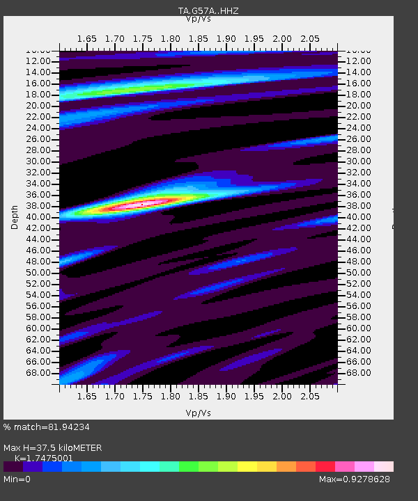
| Estimated Moho Depth: |
37.5 km |
| Estimated Crust Vp/Vs: |
1.75 |
| Assumed Crust Vp: |
6.419 km/s |
| Estimated Crust Vs: |
3.673 km/s |
| Estimated Crust Poisson's Ratio: |
0.26 |
|
| Radial Match: |
81.94234 % |
| Radial Bump: |
203 |
| Transverse Match: |
73.84107 % |
| Transverse Bump: |
385 |
| SOD ConfigId: |
7422571 |
| Insert Time: |
2019-04-19 16:19:03.926 +0000 |
| GWidth: |
2.5 |
| Max Bumps: |
400 |
| Tol: |
0.001 |
|
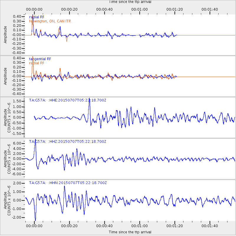
Signal To Noise
| Channel | StoN | STA | LTA |
| TA:G57A: :HHZ:20150707T05:22:18.700Z | 17.963163 | 3.0186893E-6 | 1.6804887E-7 |
| TA:G57A: :HHN:20150707T05:22:18.700Z | 4.222577 | 8.236719E-7 | 1.9506378E-7 |
| TA:G57A: :HHE:20150707T05:22:18.700Z | 9.166332 | 6.556374E-7 | 7.1526685E-8 |
| Arrivals |
| Ps | 4.5 SECOND |
| PpPs | 16 SECOND |
| PsPs/PpSs | 20 SECOND |


