You are here: Home > Network List > TA - USArray Transportable Network (new EarthScope stations) Stations List
> Station G61A St-Isidore-de-Clifton, QC, USA > Earthquake Result Viewer
G61A St-Isidore-de-Clifton, QC, USA - Earthquake Result Viewer
| Earthquake location: |
Kuril Islands |
| Earthquake latitude/longitude: |
44.0/147.9 |
| Earthquake time(UTC): |
2015/07/07 (188) 05:10:27 GMT |
| Earthquake Depth: |
38 km |
| Earthquake Magnitude: |
6.3 MO |
| Earthquake Catalog/Contributor: |
NEIC PDE/NEIC ALERT |
|
| Network: |
TA USArray Transportable Network (new EarthScope stations) |
| Station: |
G61A St-Isidore-de-Clifton, QC, USA |
| Lat/Lon: |
45.28 N/71.53 W |
| Elevation: |
378 m |
|
| Distance: |
84.5 deg |
| Az: |
26.797 deg |
| Baz: |
332.552 deg |
| Ray Param: |
0.045417923 |
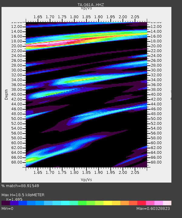
| Estimated Moho Depth: |
18.5 km |
| Estimated Crust Vp/Vs: |
1.70 |
| Assumed Crust Vp: |
6.419 km/s |
| Estimated Crust Vs: |
3.787 km/s |
| Estimated Crust Poisson's Ratio: |
0.23 |
|
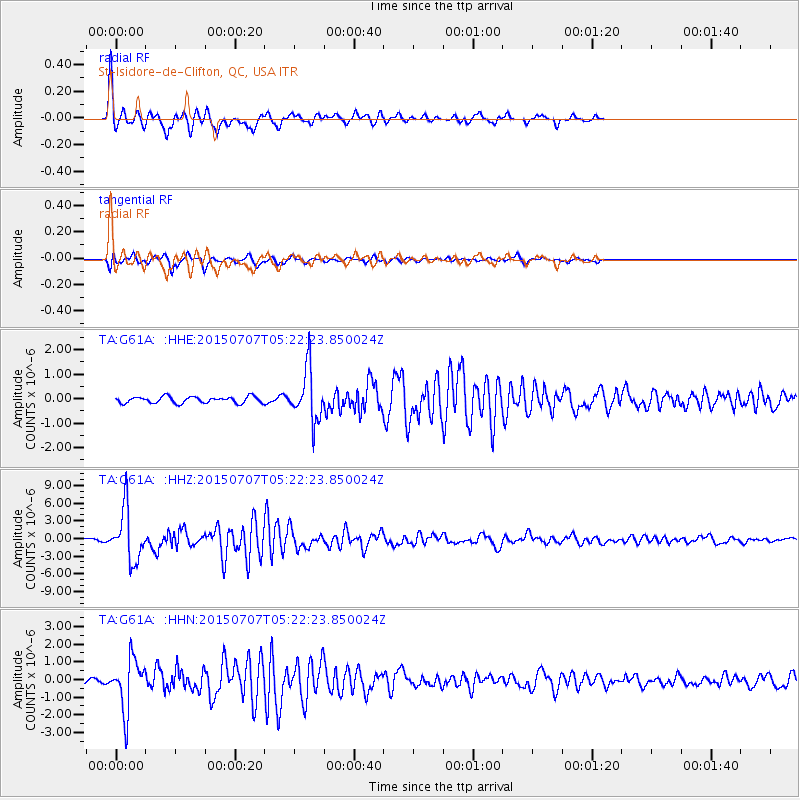
| Radial Match: |
88.91549 % |
| Radial Bump: |
336 |
| Transverse Match: |
84.6441 % |
| Transverse Bump: |
400 |
| SOD ConfigId: |
7422571 |
| Insert Time: |
2019-04-19 16:19:07.800 +0000 |
| GWidth: |
2.5 |
| Max Bumps: |
400 |
| Tol: |
0.001 |
|
Signal To Noise
| Channel | StoN | STA | LTA |
| TA:G61A: :HHZ:20150707T05:22:23.850024Z | 18.213505 | 4.378858E-6 | 2.4041822E-7 |
| TA:G61A: :HHN:20150707T05:22:23.850024Z | 4.7051477 | 1.4467425E-6 | 3.074808E-7 |
| TA:G61A: :HHE:20150707T05:22:23.850024Z | 8.014098 | 1.0801716E-6 | 1.3478392E-7 |
| Arrivals |
| Ps | 2.1 SECOND |
| PpPs | 7.6 SECOND |
| PsPs/PpSs | 9.6 SECOND |


