You are here: Home > Network List > TA - USArray Transportable Network (new EarthScope stations) Stations List
> Station G65A Princeton, ME, USA > Earthquake Result Viewer
G65A Princeton, ME, USA - Earthquake Result Viewer
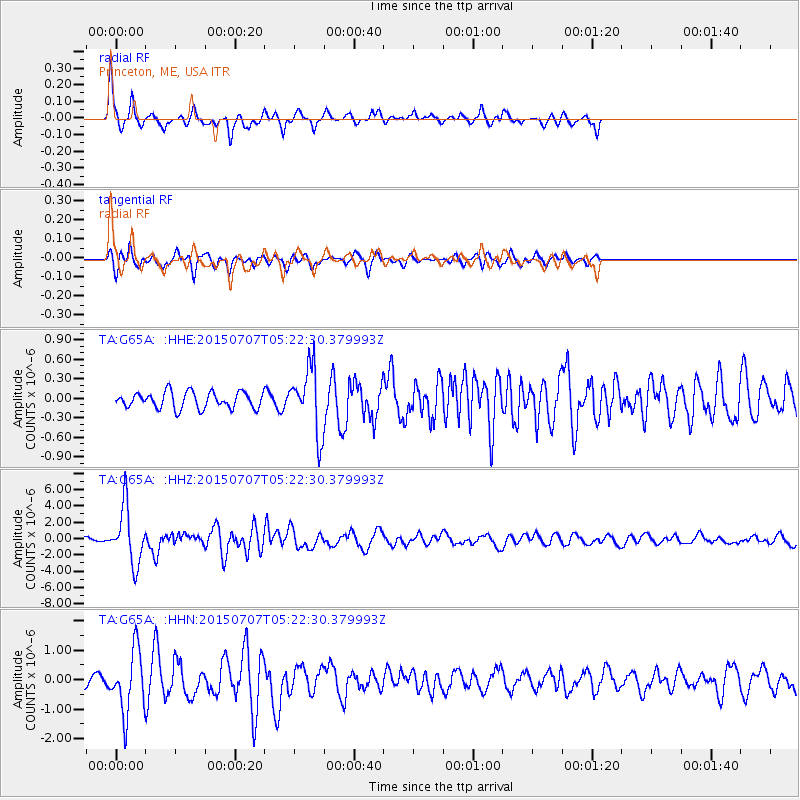
| Earthquake location: |
Kuril Islands |
| Earthquake latitude/longitude: |
44.0/147.9 |
| Earthquake time(UTC): |
2015/07/07 (188) 05:10:27 GMT |
| Earthquake Depth: |
38 km |
| Earthquake Magnitude: |
6.3 MO |
| Earthquake Catalog/Contributor: |
NEIC PDE/NEIC ALERT |
|
| Network: |
TA USArray Transportable Network (new EarthScope stations) |
| Station: |
G65A Princeton, ME, USA |
| Lat/Lon: |
45.20 N/67.56 W |
| Elevation: |
78 m |
|
| Distance: |
85.8 deg |
| Az: |
24.311 deg |
| Baz: |
335.145 deg |
| Ray Param: |
0.044479486 |
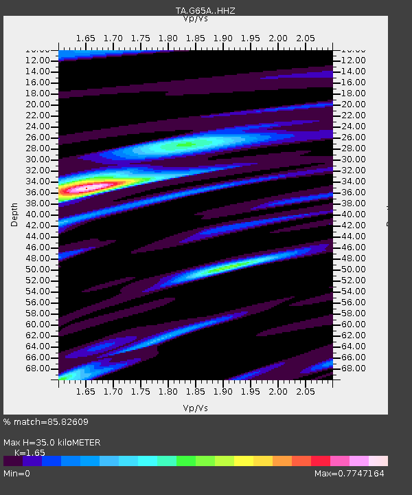
| Estimated Moho Depth: |
35.0 km |
| Estimated Crust Vp/Vs: |
1.65 |
| Assumed Crust Vp: |
6.419 km/s |
| Estimated Crust Vs: |
3.89 km/s |
| Estimated Crust Poisson's Ratio: |
0.21 |
|
| Radial Match: |
85.82609 % |
| Radial Bump: |
348 |
| Transverse Match: |
75.58288 % |
| Transverse Bump: |
330 |
| SOD ConfigId: |
7422571 |
| Insert Time: |
2019-04-19 16:19:09.548 +0000 |
| GWidth: |
2.5 |
| Max Bumps: |
400 |
| Tol: |
0.001 |
|
Signal To Noise
| Channel | StoN | STA | LTA |
| TA:G65A: :HHZ:20150707T05:22:30.379993Z | 15.087236 | 3.4399695E-6 | 2.2800528E-7 |
| TA:G65A: :HHN:20150707T05:22:30.379993Z | 6.159113 | 1.0746894E-6 | 1.744877E-7 |
| TA:G65A: :HHE:20150707T05:22:30.379993Z | 3.9363856 | 5.1386365E-7 | 1.3054199E-7 |
| Arrivals |
| Ps | 3.6 SECOND |
| PpPs | 14 SECOND |
| PsPs/PpSs | 18 SECOND |


