You are here: Home > Network List > G - GEOSCOPE Stations List
> Station MPG Montagne des Peres, French Guyana > Earthquake Result Viewer
MPG Montagne des Peres, French Guyana - Earthquake Result Viewer
| Earthquake location: |
South Sandwich Islands Region |
| Earthquake latitude/longitude: |
-55.9/-27.8 |
| Earthquake time(UTC): |
2019/04/05 (095) 16:14:16 GMT |
| Earthquake Depth: |
58 km |
| Earthquake Magnitude: |
6.5 mww |
| Earthquake Catalog/Contributor: |
NEIC PDE/us |
|
| Network: |
G GEOSCOPE |
| Station: |
MPG Montagne des Peres, French Guyana |
| Lat/Lon: |
5.11 N/52.64 W |
| Elevation: |
147 m |
|
| Distance: |
64.2 deg |
| Az: |
332.344 deg |
| Baz: |
164.797 deg |
| Ray Param: |
0.058963258 |
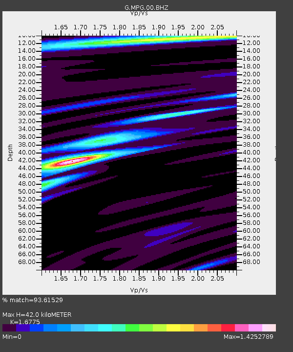
| Estimated Moho Depth: |
42.0 km |
| Estimated Crust Vp/Vs: |
1.68 |
| Assumed Crust Vp: |
6.472 km/s |
| Estimated Crust Vs: |
3.858 km/s |
| Estimated Crust Poisson's Ratio: |
0.22 |
|
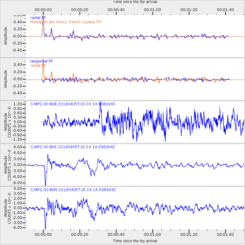
| Radial Match: |
93.61529 % |
| Radial Bump: |
385 |
| Transverse Match: |
80.38172 % |
| Transverse Bump: |
400 |
| SOD ConfigId: |
8726151 |
| Insert Time: |
2019-04-19 16:19:12.551 +0000 |
| GWidth: |
2.5 |
| Max Bumps: |
400 |
| Tol: |
0.001 |
|
Signal To Noise
| Channel | StoN | STA | LTA |
| G:MPG:00:BHZ:20190405T16:24:14.698994Z | 16.23891 | 3.5015282E-6 | 2.156258E-7 |
| G:MPG:00:BHN:20190405T16:24:14.698994Z | 7.448234 | 1.4398153E-6 | 1.9330962E-7 |
| G:MPG:00:BHE:20190405T16:24:14.698994Z | 3.2586539 | 5.65706E-7 | 1.7360112E-7 |
| Arrivals |
| Ps | 4.6 SECOND |
| PpPs | 17 SECOND |
| PsPs/PpSs | 21 SECOND |


