You are here: Home > Network List > TA - USArray Transportable Network (new EarthScope stations) Stations List
> Station H60A Morristown, VT, USA > Earthquake Result Viewer
H60A Morristown, VT, USA - Earthquake Result Viewer
| Earthquake location: |
Kuril Islands |
| Earthquake latitude/longitude: |
44.0/147.9 |
| Earthquake time(UTC): |
2015/07/07 (188) 05:10:27 GMT |
| Earthquake Depth: |
38 km |
| Earthquake Magnitude: |
6.3 MO |
| Earthquake Catalog/Contributor: |
NEIC PDE/NEIC ALERT |
|
| Network: |
TA USArray Transportable Network (new EarthScope stations) |
| Station: |
H60A Morristown, VT, USA |
| Lat/Lon: |
44.56 N/72.70 W |
| Elevation: |
459 m |
|
| Distance: |
84.7 deg |
| Az: |
27.875 deg |
| Baz: |
331.829 deg |
| Ray Param: |
0.04523812 |
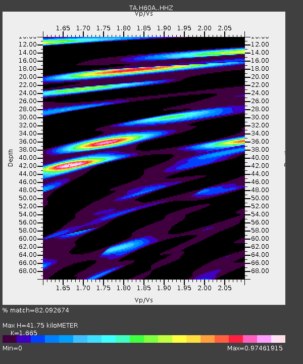
| Estimated Moho Depth: |
41.75 km |
| Estimated Crust Vp/Vs: |
1.66 |
| Assumed Crust Vp: |
6.419 km/s |
| Estimated Crust Vs: |
3.855 km/s |
| Estimated Crust Poisson's Ratio: |
0.22 |
|
| Radial Match: |
82.092674 % |
| Radial Bump: |
400 |
| Transverse Match: |
70.78709 % |
| Transverse Bump: |
400 |
| SOD ConfigId: |
7422571 |
| Insert Time: |
2019-04-19 16:19:19.452 +0000 |
| GWidth: |
2.5 |
| Max Bumps: |
400 |
| Tol: |
0.001 |
|

Signal To Noise
| Channel | StoN | STA | LTA |
| TA:H60A: :HHZ:20150707T05:22:25.100024Z | 32.491062 | 3.2034836E-6 | 9.859584E-8 |
| TA:H60A: :HHN:20150707T05:22:25.100024Z | 7.0823846 | 1.379626E-6 | 1.9479683E-7 |
| TA:H60A: :HHE:20150707T05:22:25.100024Z | 4.993909 | 7.8123617E-7 | 1.5643782E-7 |
| Arrivals |
| Ps | 4.4 SECOND |
| PpPs | 17 SECOND |
| PsPs/PpSs | 21 SECOND |


