You are here: Home > Network List > TA - USArray Transportable Network (new EarthScope stations) Stations List
> Station H66A Whiting, ME, USA > Earthquake Result Viewer
H66A Whiting, ME, USA - Earthquake Result Viewer
| Earthquake location: |
Kuril Islands |
| Earthquake latitude/longitude: |
44.0/147.9 |
| Earthquake time(UTC): |
2015/07/07 (188) 05:10:27 GMT |
| Earthquake Depth: |
38 km |
| Earthquake Magnitude: |
6.3 MO |
| Earthquake Catalog/Contributor: |
NEIC PDE/NEIC ALERT |
|
| Network: |
TA USArray Transportable Network (new EarthScope stations) |
| Station: |
H66A Whiting, ME, USA |
| Lat/Lon: |
44.79 N/67.31 W |
| Elevation: |
55 m |
|
| Distance: |
86.2 deg |
| Az: |
24.322 deg |
| Baz: |
335.324 deg |
| Ray Param: |
0.044159953 |
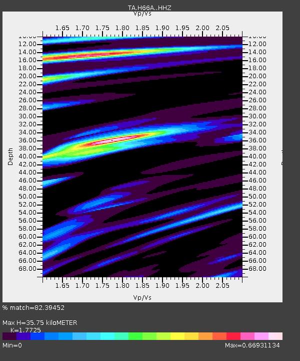
| Estimated Moho Depth: |
35.75 km |
| Estimated Crust Vp/Vs: |
1.77 |
| Assumed Crust Vp: |
6.419 km/s |
| Estimated Crust Vs: |
3.622 km/s |
| Estimated Crust Poisson's Ratio: |
0.27 |
|
| Radial Match: |
82.39452 % |
| Radial Bump: |
329 |
| Transverse Match: |
62.403145 % |
| Transverse Bump: |
400 |
| SOD ConfigId: |
7422571 |
| Insert Time: |
2019-04-19 16:19:24.238 +0000 |
| GWidth: |
2.5 |
| Max Bumps: |
400 |
| Tol: |
0.001 |
|

Signal To Noise
| Channel | StoN | STA | LTA |
| TA:H66A: :HHZ:20150707T05:22:32.600024Z | 13.541877 | 3.1976688E-6 | 2.3613187E-7 |
| TA:H66A: :HHN:20150707T05:22:32.600024Z | 6.70841 | 9.517005E-7 | 1.4186678E-7 |
| TA:H66A: :HHE:20150707T05:22:32.600024Z | 2.6980226 | 5.1024364E-7 | 1.8911761E-7 |
| Arrivals |
| Ps | 4.4 SECOND |
| PpPs | 15 SECOND |
| PsPs/PpSs | 19 SECOND |


