You are here: Home > Network List > TA - USArray Transportable Network (new EarthScope stations) Stations List
> Station I58A Old Forge, NY, USA > Earthquake Result Viewer
I58A Old Forge, NY, USA - Earthquake Result Viewer

| Earthquake location: |
Kuril Islands |
| Earthquake latitude/longitude: |
44.0/147.9 |
| Earthquake time(UTC): |
2015/07/07 (188) 05:10:27 GMT |
| Earthquake Depth: |
38 km |
| Earthquake Magnitude: |
6.3 MO |
| Earthquake Catalog/Contributor: |
NEIC PDE/NEIC ALERT |
|
| Network: |
TA USArray Transportable Network (new EarthScope stations) |
| Station: |
I58A Old Forge, NY, USA |
| Lat/Lon: |
43.69 N/74.97 W |
| Elevation: |
599 m |
|
| Distance: |
84.7 deg |
| Az: |
29.737 deg |
| Baz: |
330.423 deg |
| Ray Param: |
0.045258954 |
| Estimated Moho Depth: |
27.75 km |
| Estimated Crust Vp/Vs: |
1.78 |
| Assumed Crust Vp: |
6.419 km/s |
| Estimated Crust Vs: |
3.611 km/s |
| Estimated Crust Poisson's Ratio: |
0.27 |
|
| Radial Match: |
80.7586 % |
| Radial Bump: |
400 |
| Transverse Match: |
70.40182 % |
| Transverse Bump: |
400 |
| SOD ConfigId: |
7422571 |
| Insert Time: |
2019-04-19 16:19:30.692 +0000 |
| GWidth: |
2.5 |
| Max Bumps: |
400 |
| Tol: |
0.001 |
|
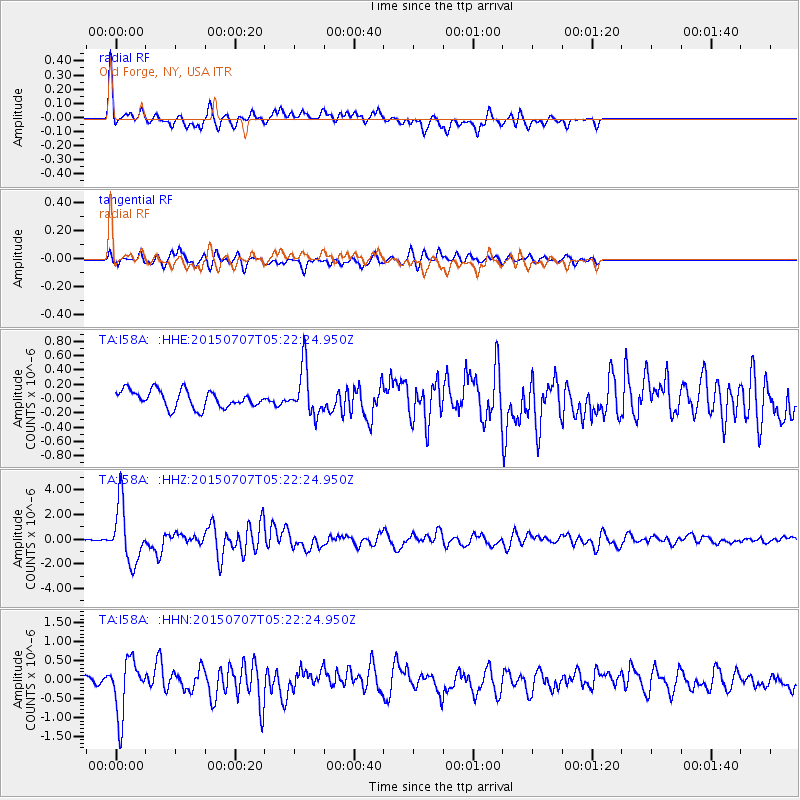
Signal To Noise
| Channel | StoN | STA | LTA |
| TA:I58A: :HHZ:20150707T05:22:24.950Z | 12.147195 | 2.350585E-6 | 1.9350844E-7 |
| TA:I58A: :HHN:20150707T05:22:24.950Z | 3.180591 | 7.2803493E-7 | 2.2889927E-7 |
| TA:I58A: :HHE:20150707T05:22:24.950Z | 2.7928221 | 3.3388704E-7 | 1.1955184E-7 |
| Arrivals |
| Ps | 3.4 SECOND |
| PpPs | 12 SECOND |
| PsPs/PpSs | 15 SECOND |


