You are here: Home > Network List > TA - USArray Transportable Network (new EarthScope stations) Stations List
> Station I64A Boothbay, ME, USA > Earthquake Result Viewer
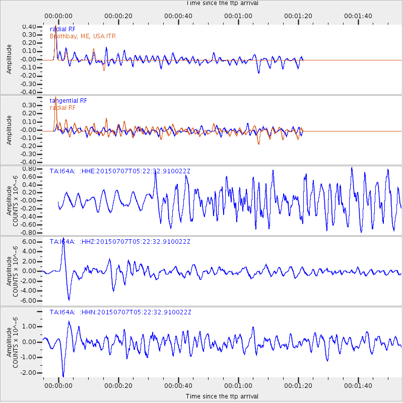
I64A Boothbay, ME, USA - Earthquake Result Viewer
*The percent match for this event was below the threshold and hence no stack was calculated.
| Earthquake location: |
Kuril Islands |
| Earthquake latitude/longitude: |
44.0/147.9 |
| Earthquake time(UTC): |
2015/07/07 (188) 05:10:27 GMT |
| Earthquake Depth: |
38 km |
| Earthquake Magnitude: |
6.3 MO |
| Earthquake Catalog/Contributor: |
NEIC PDE/NEIC ALERT |
|
| Network: |
TA USArray Transportable Network (new EarthScope stations) |
| Station: |
I64A Boothbay, ME, USA |
| Lat/Lon: |
43.92 N/69.63 W |
| Elevation: |
17 m |
|
| Distance: |
86.3 deg |
| Az: |
26.203 deg |
| Baz: |
333.828 deg |
| Ray Param: |
$rayparam |
*The percent match for this event was below the threshold and hence was not used in the summary stack. |
|
| Radial Match: |
78.41757 % |
| Radial Bump: |
400 |
| Transverse Match: |
77.08132 % |
| Transverse Bump: |
400 |
| SOD ConfigId: |
7422571 |
| Insert Time: |
2019-04-19 16:19:35.243 +0000 |
| GWidth: |
2.5 |
| Max Bumps: |
400 |
| Tol: |
0.001 |
|
Signal To Noise
| Channel | StoN | STA | LTA |
| TA:I64A: :HHZ:20150707T05:22:32.910022Z | 19.183924 | 3.2320586E-6 | 1.6847746E-7 |
| TA:I64A: :HHN:20150707T05:22:32.910022Z | 4.688905 | 9.547217E-7 | 2.0361296E-7 |
| TA:I64A: :HHE:20150707T05:22:32.910022Z | 2.0753937 | 3.0093054E-7 | 1.4499925E-7 |
| Arrivals |
| Ps | |
| PpPs | |
| PsPs/PpSs | |


