You are here: Home > Network List > TA - USArray Transportable Network (new EarthScope stations) Stations List
> Station J60A Lant Hill Farm, Argyle, NY, USA > Earthquake Result Viewer
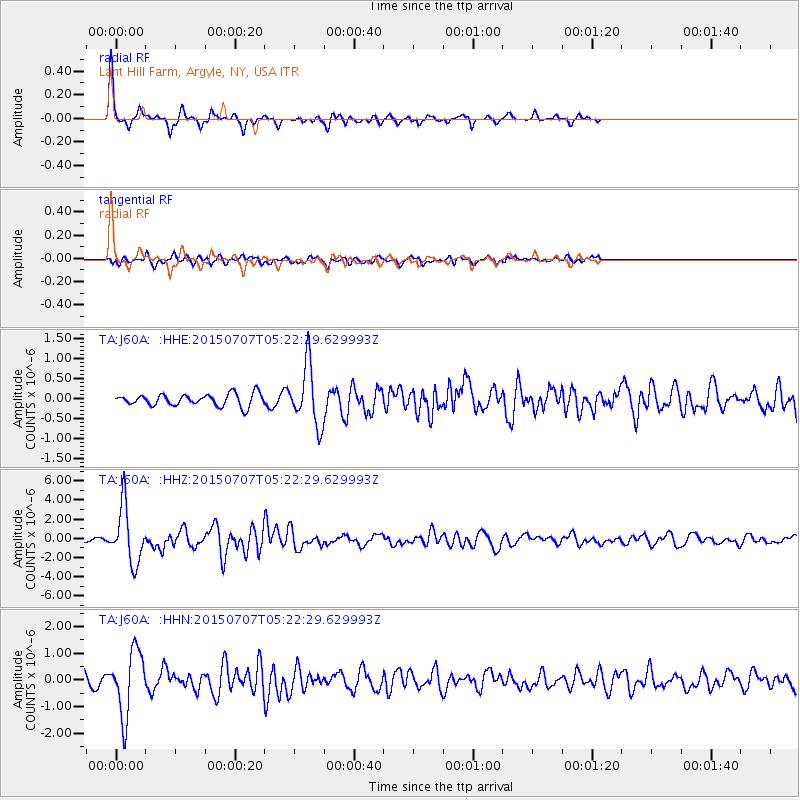
J60A Lant Hill Farm, Argyle, NY, USA - Earthquake Result Viewer

| Earthquake location: |
Kuril Islands |
| Earthquake latitude/longitude: |
44.0/147.9 |
| Earthquake time(UTC): |
2015/07/07 (188) 05:10:27 GMT |
| Earthquake Depth: |
38 km |
| Earthquake Magnitude: |
6.3 MO |
| Earthquake Catalog/Contributor: |
NEIC PDE/NEIC ALERT |
|
| Network: |
TA USArray Transportable Network (new EarthScope stations) |
| Station: |
J60A Lant Hill Farm, Argyle, NY, USA |
| Lat/Lon: |
43.24 N/73.42 W |
| Elevation: |
265 m |
|
| Distance: |
85.6 deg |
| Az: |
28.964 deg |
| Baz: |
331.422 deg |
| Ray Param: |
0.044585273 |
| Estimated Moho Depth: |
41.0 km |
| Estimated Crust Vp/Vs: |
1.77 |
| Assumed Crust Vp: |
6.419 km/s |
| Estimated Crust Vs: |
3.622 km/s |
| Estimated Crust Poisson's Ratio: |
0.27 |
|
| Radial Match: |
85.72886 % |
| Radial Bump: |
240 |
| Transverse Match: |
62.456543 % |
| Transverse Bump: |
400 |
| SOD ConfigId: |
7422571 |
| Insert Time: |
2019-04-19 16:19:40.705 +0000 |
| GWidth: |
2.5 |
| Max Bumps: |
400 |
| Tol: |
0.001 |
|
Signal To Noise
| Channel | StoN | STA | LTA |
| TA:J60A: :HHZ:20150707T05:22:29.629993Z | 26.90284 | 2.940528E-6 | 1.0930177E-7 |
| TA:J60A: :HHN:20150707T05:22:29.629993Z | 6.270406 | 1.206499E-6 | 1.9241162E-7 |
| TA:J60A: :HHE:20150707T05:22:29.629993Z | 4.989884 | 7.6275245E-7 | 1.5285976E-7 |
| Arrivals |
| Ps | 5.1 SECOND |
| PpPs | 17 SECOND |
| PsPs/PpSs | 22 SECOND |


