You are here: Home > Network List > TA - USArray Transportable Network (new EarthScope stations) Stations List
> Station L58A Harry Jones Memorial, Binghamton, NY, USA > Earthquake Result Viewer
L58A Harry Jones Memorial, Binghamton, NY, USA - Earthquake Result Viewer
| Earthquake location: |
Kuril Islands |
| Earthquake latitude/longitude: |
44.0/147.9 |
| Earthquake time(UTC): |
2015/07/07 (188) 05:10:27 GMT |
| Earthquake Depth: |
38 km |
| Earthquake Magnitude: |
6.3 MO |
| Earthquake Catalog/Contributor: |
NEIC PDE/NEIC ALERT |
|
| Network: |
TA USArray Transportable Network (new EarthScope stations) |
| Station: |
L58A Harry Jones Memorial, Binghamton, NY, USA |
| Lat/Lon: |
42.04 N/75.85 W |
| Elevation: |
447 m |
|
| Distance: |
85.8 deg |
| Az: |
31.119 deg |
| Baz: |
329.944 deg |
| Ray Param: |
0.044465866 |
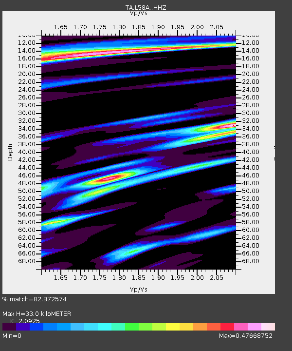
| Estimated Moho Depth: |
33.0 km |
| Estimated Crust Vp/Vs: |
2.09 |
| Assumed Crust Vp: |
6.419 km/s |
| Estimated Crust Vs: |
3.068 km/s |
| Estimated Crust Poisson's Ratio: |
0.35 |
|
| Radial Match: |
82.872574 % |
| Radial Bump: |
305 |
| Transverse Match: |
77.43011 % |
| Transverse Bump: |
383 |
| SOD ConfigId: |
7422571 |
| Insert Time: |
2019-04-19 16:19:55.868 +0000 |
| GWidth: |
2.5 |
| Max Bumps: |
400 |
| Tol: |
0.001 |
|
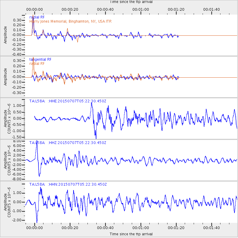
Signal To Noise
| Channel | StoN | STA | LTA |
| TA:L58A: :HHZ:20150707T05:22:30.450Z | 26.589611 | 3.733715E-6 | 1.4042007E-7 |
| TA:L58A: :HHN:20150707T05:22:30.450Z | 6.5813613 | 1.0253478E-6 | 1.557957E-7 |
| TA:L58A: :HHE:20150707T05:22:30.450Z | 9.6823015 | 7.440697E-7 | 7.684844E-8 |
| Arrivals |
| Ps | 5.7 SECOND |
| PpPs | 16 SECOND |
| PsPs/PpSs | 21 SECOND |


