You are here: Home > Network List > TA - USArray Transportable Network (new EarthScope stations) Stations List
> Station O02D Mt. Diablo Meridian, CA, USA > Earthquake Result Viewer
O02D Mt. Diablo Meridian, CA, USA - Earthquake Result Viewer

| Earthquake location: |
Kuril Islands |
| Earthquake latitude/longitude: |
44.0/147.9 |
| Earthquake time(UTC): |
2015/07/07 (188) 05:10:27 GMT |
| Earthquake Depth: |
38 km |
| Earthquake Magnitude: |
6.3 MO |
| Earthquake Catalog/Contributor: |
NEIC PDE/NEIC ALERT |
|
| Network: |
TA USArray Transportable Network (new EarthScope stations) |
| Station: |
O02D Mt. Diablo Meridian, CA, USA |
| Lat/Lon: |
40.18 N/122.79 W |
| Elevation: |
965 m |
|
| Distance: |
63.1 deg |
| Az: |
59.175 deg |
| Baz: |
305.999 deg |
| Ray Param: |
0.059697546 |
| Estimated Moho Depth: |
56.0 km |
| Estimated Crust Vp/Vs: |
1.82 |
| Assumed Crust Vp: |
6.566 km/s |
| Estimated Crust Vs: |
3.603 km/s |
| Estimated Crust Poisson's Ratio: |
0.28 |
|
| Radial Match: |
89.22943 % |
| Radial Bump: |
392 |
| Transverse Match: |
77.7968 % |
| Transverse Bump: |
400 |
| SOD ConfigId: |
7422571 |
| Insert Time: |
2019-04-19 16:20:15.044 +0000 |
| GWidth: |
2.5 |
| Max Bumps: |
400 |
| Tol: |
0.001 |
|
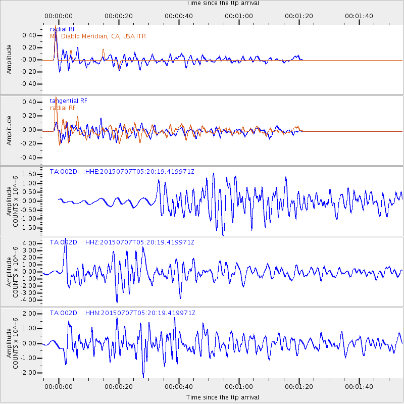
Signal To Noise
| Channel | StoN | STA | LTA |
| TA:O02D: :HHZ:20150707T05:20:19.419971Z | 14.907376 | 1.7706238E-6 | 1.1877501E-7 |
| TA:O02D: :HHN:20150707T05:20:19.419971Z | 9.5813 | 7.60103E-7 | 7.933192E-8 |
| TA:O02D: :HHE:20150707T05:20:19.419971Z | 4.727644 | 6.055975E-7 | 1.280971E-7 |
| Arrivals |
| Ps | 7.3 SECOND |
| PpPs | 23 SECOND |
| PsPs/PpSs | 30 SECOND |


