You are here: Home > Network List > TA - USArray Transportable Network (new EarthScope stations) Stations List
> Station O03E Paynes Creek, CA, USA > Earthquake Result Viewer
O03E Paynes Creek, CA, USA - Earthquake Result Viewer
| Earthquake location: |
Kuril Islands |
| Earthquake latitude/longitude: |
44.0/147.9 |
| Earthquake time(UTC): |
2015/07/07 (188) 05:10:27 GMT |
| Earthquake Depth: |
38 km |
| Earthquake Magnitude: |
6.3 MO |
| Earthquake Catalog/Contributor: |
NEIC PDE/NEIC ALERT |
|
| Network: |
TA USArray Transportable Network (new EarthScope stations) |
| Station: |
O03E Paynes Creek, CA, USA |
| Lat/Lon: |
40.29 N/121.80 W |
| Elevation: |
967 m |
|
| Distance: |
63.7 deg |
| Az: |
58.57 deg |
| Baz: |
306.363 deg |
| Ray Param: |
0.059346985 |
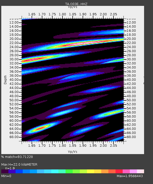
| Estimated Moho Depth: |
22.0 km |
| Estimated Crust Vp/Vs: |
1.90 |
| Assumed Crust Vp: |
6.566 km/s |
| Estimated Crust Vs: |
3.456 km/s |
| Estimated Crust Poisson's Ratio: |
0.31 |
|
| Radial Match: |
93.71228 % |
| Radial Bump: |
386 |
| Transverse Match: |
91.06653 % |
| Transverse Bump: |
385 |
| SOD ConfigId: |
7422571 |
| Insert Time: |
2019-04-19 16:20:16.577 +0000 |
| GWidth: |
2.5 |
| Max Bumps: |
400 |
| Tol: |
0.001 |
|
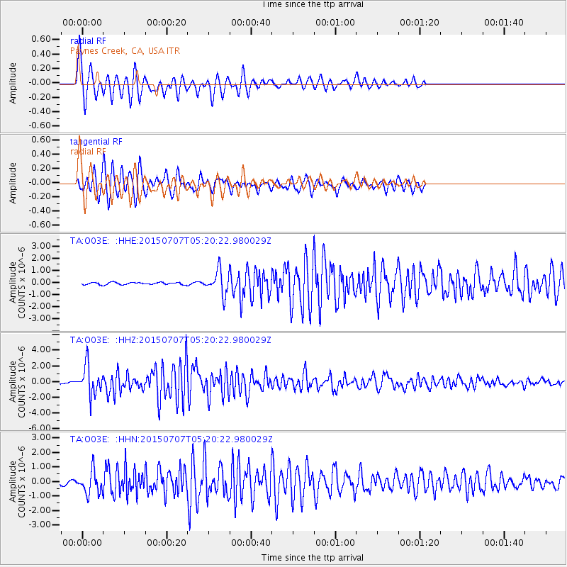
Signal To Noise
| Channel | StoN | STA | LTA |
| TA:O03E: :HHZ:20150707T05:20:22.980029Z | 28.640673 | 1.9054357E-6 | 6.652901E-8 |
| TA:O03E: :HHN:20150707T05:20:22.980029Z | 7.133959 | 7.995668E-7 | 1.1207898E-7 |
| TA:O03E: :HHE:20150707T05:20:22.980029Z | 11.8864 | 1.0923613E-6 | 9.19001E-8 |
| Arrivals |
| Ps | 3.1 SECOND |
| PpPs | 9.3 SECOND |
| PsPs/PpSs | 12 SECOND |


