You are here: Home > Network List > TA - USArray Transportable Network (new EarthScope stations) Stations List
> Station O20K Slope Mountain, AK, USA > Earthquake Result Viewer
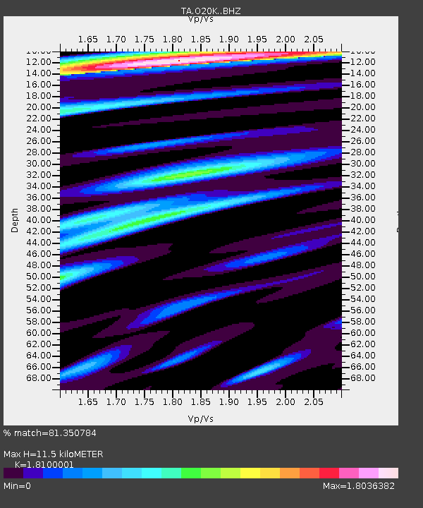
O20K Slope Mountain, AK, USA - Earthquake Result Viewer
| Earthquake location: |
Kuril Islands |
| Earthquake latitude/longitude: |
44.0/147.9 |
| Earthquake time(UTC): |
2015/07/07 (188) 05:10:27 GMT |
| Earthquake Depth: |
38 km |
| Earthquake Magnitude: |
6.3 MO |
| Earthquake Catalog/Contributor: |
NEIC PDE/NEIC ALERT |
|
| Network: |
TA USArray Transportable Network (new EarthScope stations) |
| Station: |
O20K Slope Mountain, AK, USA |
| Lat/Lon: |
60.08 N/152.62 W |
| Elevation: |
915 m |
|
| Distance: |
38.5 deg |
| Az: |
43.923 deg |
| Baz: |
272.704 deg |
| Ray Param: |
0.075454496 |
| Estimated Moho Depth: |
11.5 km |
| Estimated Crust Vp/Vs: |
1.81 |
| Assumed Crust Vp: |
6.566 km/s |
| Estimated Crust Vs: |
3.628 km/s |
| Estimated Crust Poisson's Ratio: |
0.28 |
|
| Radial Match: |
81.350784 % |
| Radial Bump: |
400 |
| Transverse Match: |
71.332954 % |
| Transverse Bump: |
400 |
| SOD ConfigId: |
7422571 |
| Insert Time: |
2019-04-19 16:20:17.292 +0000 |
| GWidth: |
2.5 |
| Max Bumps: |
400 |
| Tol: |
0.001 |
|

Signal To Noise
| Channel | StoN | STA | LTA |
| TA:O20K: :BHZ:20150707T05:17:14.400012Z | 20.604164 | 7.1985774E-6 | 3.4937486E-7 |
| TA:O20K: :BHN:20150707T05:17:14.400012Z | 5.855281 | 2.297109E-6 | 3.9231404E-7 |
| TA:O20K: :BHE:20150707T05:17:14.400012Z | 8.728171 | 3.3764607E-6 | 3.868463E-7 |
| Arrivals |
| Ps | 1.5 SECOND |
| PpPs | 4.6 SECOND |
| PsPs/PpSs | 6.1 SECOND |


