You are here: Home > Network List > TA - USArray Transportable Network (new EarthScope stations) Stations List
> Station P19K Oil Pt, AK, USA > Earthquake Result Viewer
P19K Oil Pt, AK, USA - Earthquake Result Viewer
| Earthquake location: |
Kuril Islands |
| Earthquake latitude/longitude: |
44.0/147.9 |
| Earthquake time(UTC): |
2015/07/07 (188) 05:10:27 GMT |
| Earthquake Depth: |
38 km |
| Earthquake Magnitude: |
6.3 MO |
| Earthquake Catalog/Contributor: |
NEIC PDE/NEIC ALERT |
|
| Network: |
TA USArray Transportable Network (new EarthScope stations) |
| Station: |
P19K Oil Pt, AK, USA |
| Lat/Lon: |
59.65 N/153.23 W |
| Elevation: |
629 m |
|
| Distance: |
38.2 deg |
| Az: |
44.639 deg |
| Baz: |
272.741 deg |
| Ray Param: |
0.07561941 |
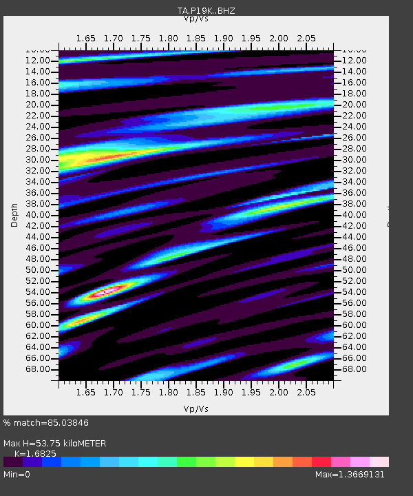
| Estimated Moho Depth: |
53.75 km |
| Estimated Crust Vp/Vs: |
1.68 |
| Assumed Crust Vp: |
5.989 km/s |
| Estimated Crust Vs: |
3.56 km/s |
| Estimated Crust Poisson's Ratio: |
0.23 |
|
| Radial Match: |
85.03846 % |
| Radial Bump: |
400 |
| Transverse Match: |
74.56724 % |
| Transverse Bump: |
400 |
| SOD ConfigId: |
7422571 |
| Insert Time: |
2019-04-19 16:20:22.416 +0000 |
| GWidth: |
2.5 |
| Max Bumps: |
400 |
| Tol: |
0.001 |
|

Signal To Noise
| Channel | StoN | STA | LTA |
| TA:P19K: :BHZ:20150707T05:17:11.999988Z | 30.157688 | 8.110443E-6 | 2.6893449E-7 |
| TA:P19K: :BHN:20150707T05:17:11.999988Z | 3.3151662 | 1.1866316E-6 | 3.579403E-7 |
| TA:P19K: :BHE:20150707T05:17:11.999988Z | 7.892275 | 2.7175206E-6 | 3.4432668E-7 |
| Arrivals |
| Ps | 6.5 SECOND |
| PpPs | 23 SECOND |
| PsPs/PpSs | 29 SECOND |


