You are here: Home > Network List > TA - USArray Transportable Network (new EarthScope stations) Stations List
> Station TPFO Pinon Flats, CA, USA > Earthquake Result Viewer
TPFO Pinon Flats, CA, USA - Earthquake Result Viewer
| Earthquake location: |
Kuril Islands |
| Earthquake latitude/longitude: |
44.0/147.9 |
| Earthquake time(UTC): |
2015/07/07 (188) 05:10:27 GMT |
| Earthquake Depth: |
38 km |
| Earthquake Magnitude: |
6.3 MO |
| Earthquake Catalog/Contributor: |
NEIC PDE/NEIC ALERT |
|
| Network: |
TA USArray Transportable Network (new EarthScope stations) |
| Station: |
TPFO Pinon Flats, CA, USA |
| Lat/Lon: |
33.61 N/116.45 W |
| Elevation: |
1275 m |
|
| Distance: |
71.2 deg |
| Az: |
61.332 deg |
| Baz: |
310.633 deg |
| Ray Param: |
0.054428034 |
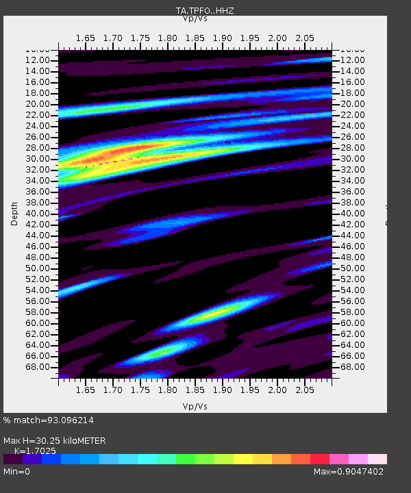
| Estimated Moho Depth: |
30.25 km |
| Estimated Crust Vp/Vs: |
1.70 |
| Assumed Crust Vp: |
6.264 km/s |
| Estimated Crust Vs: |
3.679 km/s |
| Estimated Crust Poisson's Ratio: |
0.24 |
|
| Radial Match: |
93.096214 % |
| Radial Bump: |
371 |
| Transverse Match: |
81.18078 % |
| Transverse Bump: |
374 |
| SOD ConfigId: |
7422571 |
| Insert Time: |
2019-04-19 16:20:32.970 +0000 |
| GWidth: |
2.5 |
| Max Bumps: |
400 |
| Tol: |
0.001 |
|
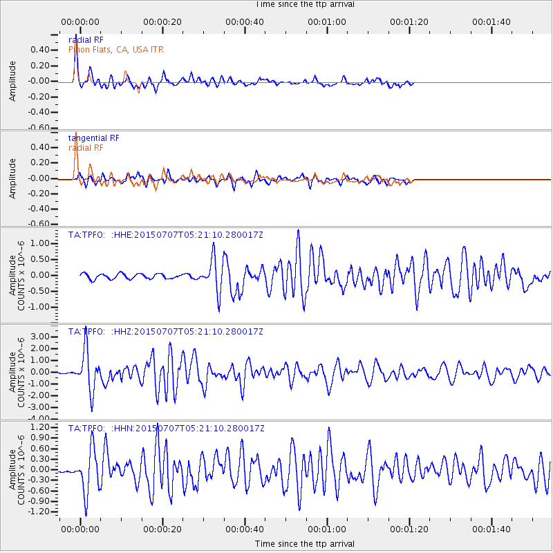
Signal To Noise
| Channel | StoN | STA | LTA |
| TA:TPFO: :HHZ:20150707T05:21:10.280017Z | 22.308992 | 1.755545E-6 | 7.869226E-8 |
| TA:TPFO: :HHN:20150707T05:21:10.280017Z | 11.032263 | 6.389802E-7 | 5.7919234E-8 |
| TA:TPFO: :HHE:20150707T05:21:10.280017Z | 7.305259 | 5.889284E-7 | 8.061704E-8 |
| Arrivals |
| Ps | 3.5 SECOND |
| PpPs | 13 SECOND |
| PsPs/PpSs | 16 SECOND |


