You are here: Home > Network List > TD - TransAlta Monitoring Network Stations List
> Station TD008 Z > Earthquake Result Viewer
TD008 Z - Earthquake Result Viewer
| Earthquake location: |
Kuril Islands |
| Earthquake latitude/longitude: |
44.0/147.9 |
| Earthquake time(UTC): |
2015/07/07 (188) 05:10:27 GMT |
| Earthquake Depth: |
38 km |
| Earthquake Magnitude: |
6.3 MO |
| Earthquake Catalog/Contributor: |
NEIC PDE/NEIC ALERT |
|
| Network: |
TD TransAlta Monitoring Network |
| Station: |
TD008 Z |
| Lat/Lon: |
52.80 N/115.43 W |
| Elevation: |
964 m |
|
| Distance: |
60.0 deg |
| Az: |
44.109 deg |
| Baz: |
304.152 deg |
| Ray Param: |
0.06171825 |
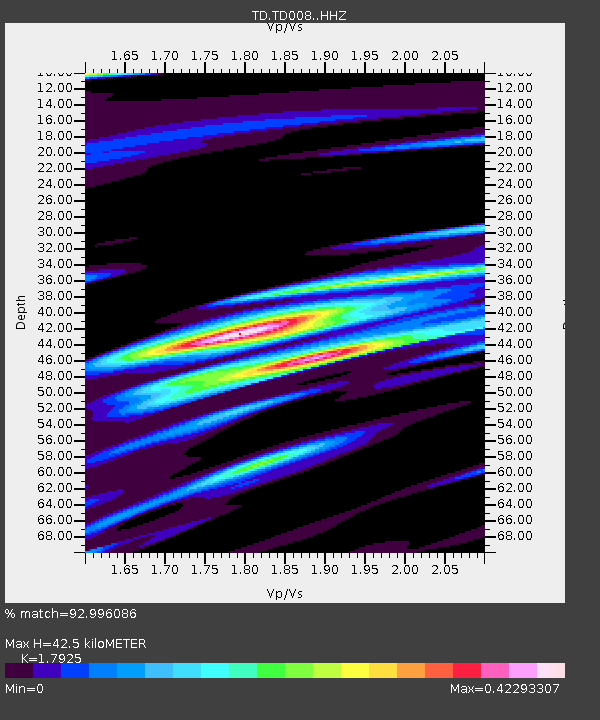
| Estimated Moho Depth: |
42.5 km |
| Estimated Crust Vp/Vs: |
1.79 |
| Assumed Crust Vp: |
6.426 km/s |
| Estimated Crust Vs: |
3.585 km/s |
| Estimated Crust Poisson's Ratio: |
0.27 |
|
| Radial Match: |
92.996086 % |
| Radial Bump: |
399 |
| Transverse Match: |
83.40756 % |
| Transverse Bump: |
400 |
| SOD ConfigId: |
7422571 |
| Insert Time: |
2019-04-19 16:20:43.231 +0000 |
| GWidth: |
2.5 |
| Max Bumps: |
400 |
| Tol: |
0.001 |
|

Signal To Noise
| Channel | StoN | STA | LTA |
| TD:TD008: :HHZ:20150707T05:19:58.660022Z | 22.251133 | 4.8644974E-6 | 2.1861797E-7 |
| TD:TD008: :HH1:20150707T05:19:58.660022Z | 5.5006986 | 1.1165607E-6 | 2.0298526E-7 |
| TD:TD008: :HH2:20150707T05:19:58.660022Z | 10.680367 | 1.9205006E-6 | 1.7981598E-7 |
| Arrivals |
| Ps | 5.5 SECOND |
| PpPs | 18 SECOND |
| PsPs/PpSs | 23 SECOND |


