You are here: Home > Network List > TD - TransAlta Monitoring Network Stations List
> Station TD016 Z > Earthquake Result Viewer
TD016 Z - Earthquake Result Viewer
| Earthquake location: |
Kuril Islands |
| Earthquake latitude/longitude: |
44.0/147.9 |
| Earthquake time(UTC): |
2015/07/07 (188) 05:10:27 GMT |
| Earthquake Depth: |
38 km |
| Earthquake Magnitude: |
6.3 MO |
| Earthquake Catalog/Contributor: |
NEIC PDE/NEIC ALERT |
|
| Network: |
TD TransAlta Monitoring Network |
| Station: |
TD016 Z |
| Lat/Lon: |
51.21 N/114.84 W |
| Elevation: |
1380 m |
|
| Distance: |
61.3 deg |
| Az: |
45.374 deg |
| Baz: |
305.241 deg |
| Ray Param: |
0.06091864 |
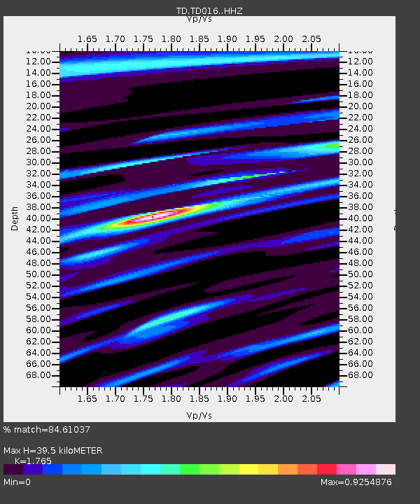
| Estimated Moho Depth: |
39.5 km |
| Estimated Crust Vp/Vs: |
1.76 |
| Assumed Crust Vp: |
6.178 km/s |
| Estimated Crust Vs: |
3.5 km/s |
| Estimated Crust Poisson's Ratio: |
0.26 |
|
| Radial Match: |
84.61037 % |
| Radial Bump: |
307 |
| Transverse Match: |
85.287056 % |
| Transverse Bump: |
400 |
| SOD ConfigId: |
7422571 |
| Insert Time: |
2019-04-19 16:20:46.123 +0000 |
| GWidth: |
2.5 |
| Max Bumps: |
400 |
| Tol: |
0.001 |
|

Signal To Noise
| Channel | StoN | STA | LTA |
| TD:TD016: :HHZ:20150707T05:20:06.879993Z | 27.82459 | 3.3639524E-6 | 1.2089855E-7 |
| TD:TD016: :HH1:20150707T05:20:06.879993Z | 5.0375757 | 6.9891007E-7 | 1.3873937E-7 |
| TD:TD016: :HH2:20150707T05:20:06.879993Z | 6.0919776 | 1.309898E-6 | 2.1502018E-7 |
| Arrivals |
| Ps | 5.1 SECOND |
| PpPs | 17 SECOND |
| PsPs/PpSs | 22 SECOND |


