You are here: Home > Network List > TO - Tectonic Observatory Stations List
> Station CC35 CCSE CC35 > Earthquake Result Viewer
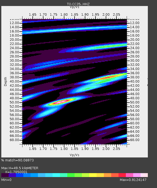
CC35 CCSE CC35 - Earthquake Result Viewer
| Earthquake location: |
Kuril Islands |
| Earthquake latitude/longitude: |
44.0/147.9 |
| Earthquake time(UTC): |
2015/07/07 (188) 05:10:27 GMT |
| Earthquake Depth: |
38 km |
| Earthquake Magnitude: |
6.3 MO |
| Earthquake Catalog/Contributor: |
NEIC PDE/NEIC ALERT |
|
| Network: |
TO Tectonic Observatory |
| Station: |
CC35 CCSE CC35 |
| Lat/Lon: |
36.38 N/119.01 W |
| Elevation: |
194 m |
|
| Distance: |
67.8 deg |
| Az: |
60.495 deg |
| Baz: |
308.883 deg |
| Ray Param: |
0.056644887 |
| Estimated Moho Depth: |
49.5 km |
| Estimated Crust Vp/Vs: |
1.79 |
| Assumed Crust Vp: |
6.291 km/s |
| Estimated Crust Vs: |
3.525 km/s |
| Estimated Crust Poisson's Ratio: |
0.27 |
|
| Radial Match: |
90.06973 % |
| Radial Bump: |
305 |
| Transverse Match: |
81.64531 % |
| Transverse Bump: |
400 |
| SOD ConfigId: |
7422571 |
| Insert Time: |
2019-04-19 16:21:22.022 +0000 |
| GWidth: |
2.5 |
| Max Bumps: |
400 |
| Tol: |
0.001 |
|

Signal To Noise
| Channel | StoN | STA | LTA |
| TO:CC35: :HHZ:20150707T05:20:49.509998Z | 28.41167 | 1.509785E-6 | 5.3139605E-8 |
| TO:CC35: :HHN:20150707T05:20:49.509998Z | 8.439113 | 5.008209E-7 | 5.9345204E-8 |
| TO:CC35: :HHE:20150707T05:20:49.509998Z | 15.654435 | 6.659767E-7 | 4.2542364E-8 |
| Arrivals |
| Ps | 6.4 SECOND |
| PpPs | 21 SECOND |
| PsPs/PpSs | 28 SECOND |


