You are here: Home > Network List > US - United States National Seismic Network Stations List
> Station OGNE Ogallala, Nebraska, USA > Earthquake Result Viewer
OGNE Ogallala, Nebraska, USA - Earthquake Result Viewer
| Earthquake location: |
Kuril Islands |
| Earthquake latitude/longitude: |
44.0/147.9 |
| Earthquake time(UTC): |
2015/07/07 (188) 05:10:27 GMT |
| Earthquake Depth: |
38 km |
| Earthquake Magnitude: |
6.3 MO |
| Earthquake Catalog/Contributor: |
NEIC PDE/NEIC ALERT |
|
| Network: |
US United States National Seismic Network |
| Station: |
OGNE Ogallala, Nebraska, USA |
| Lat/Lon: |
40.95 N/102.03 W |
| Elevation: |
1054 m |
|
| Distance: |
74.7 deg |
| Az: |
47.559 deg |
| Baz: |
315.314 deg |
| Ray Param: |
0.052121438 |
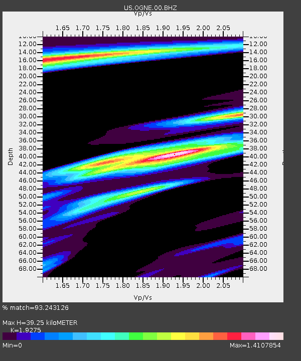
| Estimated Moho Depth: |
39.25 km |
| Estimated Crust Vp/Vs: |
1.93 |
| Assumed Crust Vp: |
6.483 km/s |
| Estimated Crust Vs: |
3.363 km/s |
| Estimated Crust Poisson's Ratio: |
0.32 |
|
| Radial Match: |
93.243126 % |
| Radial Bump: |
338 |
| Transverse Match: |
64.4292 % |
| Transverse Bump: |
370 |
| SOD ConfigId: |
7422571 |
| Insert Time: |
2019-04-19 16:21:36.971 +0000 |
| GWidth: |
2.5 |
| Max Bumps: |
400 |
| Tol: |
0.001 |
|

Signal To Noise
| Channel | StoN | STA | LTA |
| US:OGNE:00:BHZ:20150707T05:21:30.824023Z | 41.360893 | 4.5222305E-6 | 1.093359E-7 |
| US:OGNE:00:BH1:20150707T05:21:30.824023Z | 3.218809 | 1.8587407E-6 | 5.774623E-7 |
| US:OGNE:00:BH2:20150707T05:21:30.824023Z | 6.6196184 | 1.8081474E-6 | 2.731498E-7 |
| Arrivals |
| Ps | 5.8 SECOND |
| PpPs | 17 SECOND |
| PsPs/PpSs | 23 SECOND |


