You are here: Home > Network List > UW - Pacific Northwest Regional Seismic Network Stations List
> Station MRBL Marblemount, WA, USA > Earthquake Result Viewer
MRBL Marblemount, WA, USA - Earthquake Result Viewer
| Earthquake location: |
Kuril Islands |
| Earthquake latitude/longitude: |
44.0/147.9 |
| Earthquake time(UTC): |
2015/07/07 (188) 05:10:27 GMT |
| Earthquake Depth: |
38 km |
| Earthquake Magnitude: |
6.3 MO |
| Earthquake Catalog/Contributor: |
NEIC PDE/NEIC ALERT |
|
| Network: |
UW Pacific Northwest Regional Seismic Network |
| Station: |
MRBL Marblemount, WA, USA |
| Lat/Lon: |
48.52 N/121.48 W |
| Elevation: |
75 m |
|
| Distance: |
59.2 deg |
| Az: |
50.717 deg |
| Baz: |
302.823 deg |
| Ray Param: |
0.062273998 |
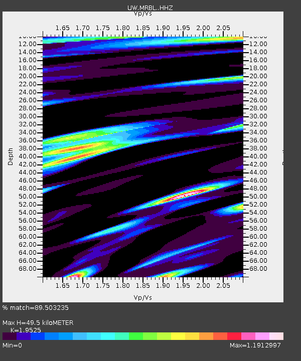
| Estimated Moho Depth: |
49.5 km |
| Estimated Crust Vp/Vs: |
1.95 |
| Assumed Crust Vp: |
6.566 km/s |
| Estimated Crust Vs: |
3.363 km/s |
| Estimated Crust Poisson's Ratio: |
0.32 |
|
| Radial Match: |
89.503235 % |
| Radial Bump: |
400 |
| Transverse Match: |
87.994 % |
| Transverse Bump: |
400 |
| SOD ConfigId: |
7422571 |
| Insert Time: |
2019-04-19 16:21:59.629 +0000 |
| GWidth: |
2.5 |
| Max Bumps: |
400 |
| Tol: |
0.001 |
|
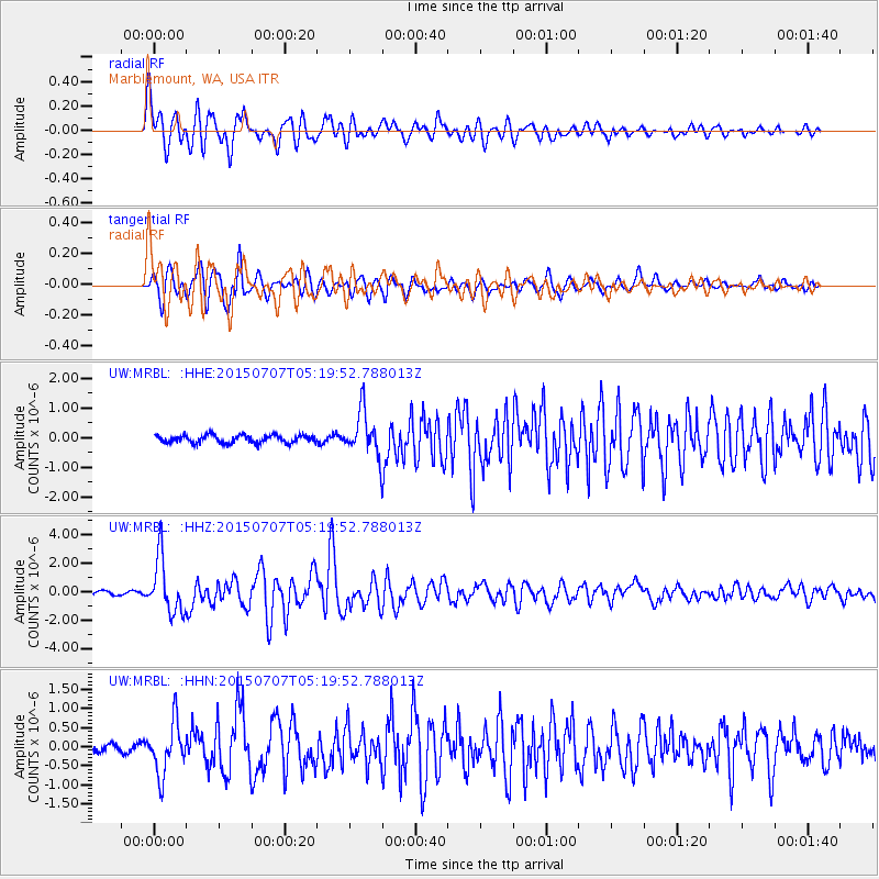
Signal To Noise
| Channel | StoN | STA | LTA |
| UW:MRBL: :HHZ:20150707T05:19:52.788013Z | 13.440691 | 1.907058E-6 | 1.418869E-7 |
| UW:MRBL: :HHN:20150707T05:19:52.788013Z | 5.927188 | 6.657644E-7 | 1.1232382E-7 |
| UW:MRBL: :HHE:20150707T05:19:52.788013Z | 6.5926466 | 8.8558704E-7 | 1.3432953E-7 |
| Arrivals |
| Ps | 7.5 SECOND |
| PpPs | 21 SECOND |
| PsPs/PpSs | 29 SECOND |


