You are here: Home > Network List > XD14 - Illuminating the architecture of the greater Mount St. Helens magmatic systems f Stations List
> Station MK06 "Mount St Helens, WA" > Earthquake Result Viewer
MK06 "Mount St Helens, WA" - Earthquake Result Viewer
| Earthquake location: |
Kuril Islands |
| Earthquake latitude/longitude: |
44.0/147.9 |
| Earthquake time(UTC): |
2015/07/07 (188) 05:10:27 GMT |
| Earthquake Depth: |
38 km |
| Earthquake Magnitude: |
6.3 MO |
| Earthquake Catalog/Contributor: |
NEIC PDE/NEIC ALERT |
|
| Network: |
XD Illuminating the architecture of the greater Mount St. Helens magmatic systems f |
| Station: |
MK06 "Mount St Helens, WA" |
| Lat/Lon: |
46.12 N/122.19 W |
| Elevation: |
680 m |
|
| Distance: |
60.1 deg |
| Az: |
53.351 deg |
| Baz: |
303.635 deg |
| Ray Param: |
0.06167636 |
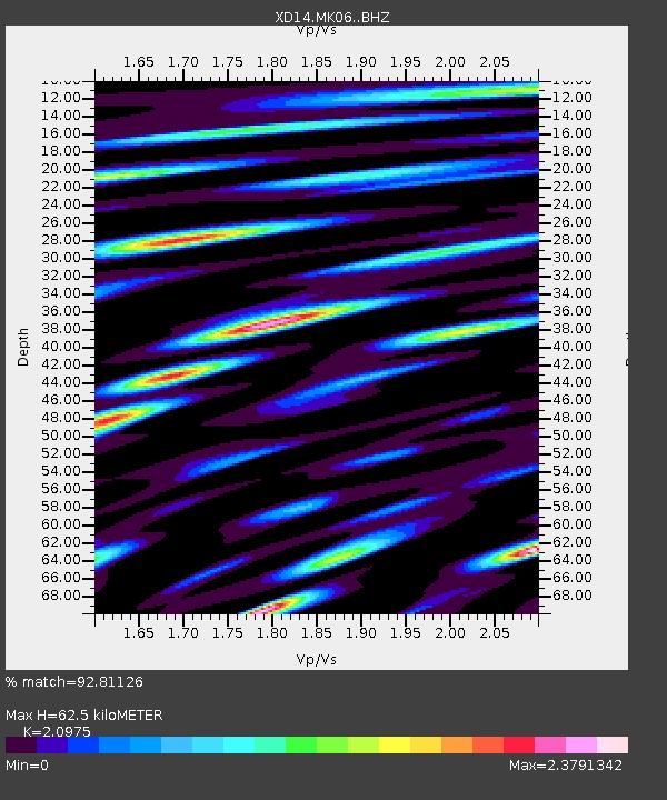
| Estimated Moho Depth: |
62.5 km |
| Estimated Crust Vp/Vs: |
2.10 |
| Assumed Crust Vp: |
6.566 km/s |
| Estimated Crust Vs: |
3.13 km/s |
| Estimated Crust Poisson's Ratio: |
0.35 |
|
| Radial Match: |
92.81126 % |
| Radial Bump: |
400 |
| Transverse Match: |
88.19402 % |
| Transverse Bump: |
400 |
| SOD ConfigId: |
7422571 |
| Insert Time: |
2019-04-19 16:23:13.220 +0000 |
| GWidth: |
2.5 |
| Max Bumps: |
400 |
| Tol: |
0.001 |
|

Signal To Noise
| Channel | StoN | STA | LTA |
| XD:MK06: :BHZ:20150707T05:19:59.044971Z | 34.236694 | 2.9092535E-6 | 8.497472E-8 |
| XD:MK06: :BHN:20150707T05:19:59.044971Z | 5.7382407 | 7.8503604E-7 | 1.368078E-7 |
| XD:MK06: :BHE:20150707T05:19:59.044971Z | 10.703344 | 1.6616316E-6 | 1.5524415E-7 |
| Arrivals |
| Ps | 11 SECOND |
| PpPs | 28 SECOND |
| PsPs/PpSs | 39 SECOND |


